You are here: Home > Network List > II - Global Seismograph Network (GSN - IRIS/IDA) Stations List
> Station NIL Nilore, Pakistan > Earthquake Result Viewer
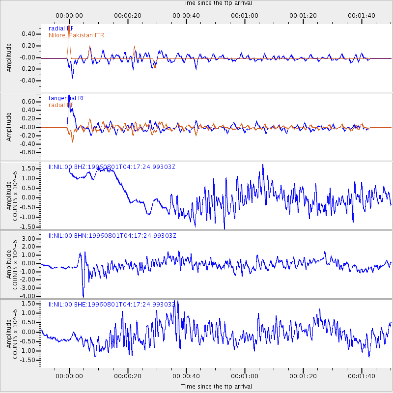
NIL Nilore, Pakistan - Earthquake Result Viewer
*The percent match for this event was below the threshold and hence no stack was calculated.
| Earthquake location: |
Minahassa Peninsula, Sulawesi |
| Earthquake latitude/longitude: |
-0.0/122.9 |
| Earthquake time(UTC): |
1996/08/01 (214) 04:08:23 GMT |
| Earthquake Depth: |
149 km |
| Earthquake Magnitude: |
5.5 MB, 5.6 UNKNOWN, 5.5 MW |
| Earthquake Catalog/Contributor: |
WHDF/NEIC |
|
| Network: |
II Global Seismograph Network (GSN - IRIS/IDA) |
| Station: |
NIL Nilore, Pakistan |
| Lat/Lon: |
33.65 N/73.27 E |
| Elevation: |
629 m |
|
| Distance: |
57.3 deg |
| Az: |
310.946 deg |
| Baz: |
115.107 deg |
| Ray Param: |
$rayparam |
*The percent match for this event was below the threshold and hence was not used in the summary stack. |
|
| Radial Match: |
82.43767 % |
| Radial Bump: |
400 |
| Transverse Match: |
94.18517 % |
| Transverse Bump: |
400 |
| SOD ConfigId: |
4480 |
| Insert Time: |
2010-03-02 00:31:46.784 +0000 |
| GWidth: |
2.5 |
| Max Bumps: |
400 |
| Tol: |
0.001 |
|
Signal To Noise
| Channel | StoN | STA | LTA |
| II:NIL:00:BHN:19960801T04:17:24.99303Z | 2.5211585 | 1.6961357E-6 | 6.727604E-7 |
| II:NIL:00:BHE:19960801T04:17:24.99303Z | 2.0004044 | 1.2107656E-6 | 6.052604E-7 |
| II:NIL:00:BHZ:19960801T04:17:24.99303Z | 2.1360524 | 1.260004E-6 | 5.89875E-7 |
| Arrivals |
| Ps | |
| PpPs | |
| PsPs/PpSs | |


