You are here: Home > Network List > AK - Alaska Regional Network Stations List
> Station BESE Bessie Mountain > Earthquake Result Viewer
BESE Bessie Mountain - Earthquake Result Viewer
| Earthquake location: |
Oaxaca, Mexico |
| Earthquake latitude/longitude: |
17.8/-95.5 |
| Earthquake time(UTC): |
2014/07/29 (210) 10:46:15 GMT |
| Earthquake Depth: |
95 km |
| Earthquake Magnitude: |
6.3 MWP |
| Earthquake Catalog/Contributor: |
NEIC PDE/NEIC COMCAT |
|
| Network: |
AK Alaska Regional Network |
| Station: |
BESE Bessie Mountain |
| Lat/Lon: |
58.58 N/134.85 W |
| Elevation: |
870 m |
|
| Distance: |
49.8 deg |
| Az: |
334.237 deg |
| Baz: |
127.787 deg |
| Ray Param: |
0.06816576 |
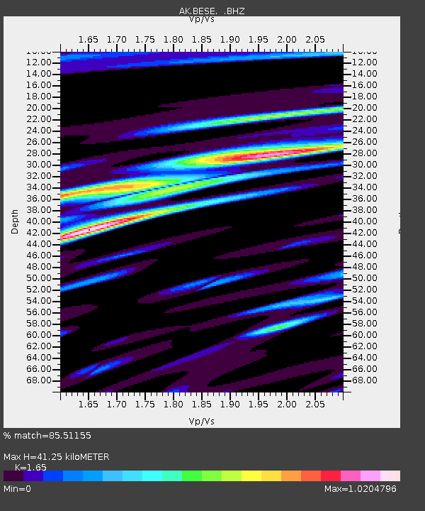
| Estimated Moho Depth: |
41.25 km |
| Estimated Crust Vp/Vs: |
1.65 |
| Assumed Crust Vp: |
6.566 km/s |
| Estimated Crust Vs: |
3.98 km/s |
| Estimated Crust Poisson's Ratio: |
0.21 |
|
| Radial Match: |
85.51155 % |
| Radial Bump: |
400 |
| Transverse Match: |
77.973755 % |
| Transverse Bump: |
400 |
| SOD ConfigId: |
769524 |
| Insert Time: |
2014-08-12 10:48:36.636 +0000 |
| GWidth: |
2.5 |
| Max Bumps: |
400 |
| Tol: |
0.001 |
|

Signal To Noise
| Channel | StoN | STA | LTA |
| AK:BESE: :BHZ:20140729T10:54:27.848Z | 39.70587 | 1.9228526E-6 | 4.8427413E-8 |
| AK:BESE: :BHN:20140729T10:54:27.848Z | 6.1908236 | 4.818425E-7 | 7.783173E-8 |
| AK:BESE: :BHE:20140729T10:54:27.848Z | 8.168615 | 8.747454E-7 | 1.0708613E-7 |
| Arrivals |
| Ps | 4.4 SECOND |
| PpPs | 16 SECOND |
| PsPs/PpSs | 20 SECOND |


