You are here: Home > Network List > AK - Alaska Regional Network Stations List
> Station GRIN Grindle Hills, AK, USA > Earthquake Result Viewer
GRIN Grindle Hills, AK, USA - Earthquake Result Viewer
| Earthquake location: |
Oaxaca, Mexico |
| Earthquake latitude/longitude: |
17.8/-95.5 |
| Earthquake time(UTC): |
2014/07/29 (210) 10:46:15 GMT |
| Earthquake Depth: |
95 km |
| Earthquake Magnitude: |
6.3 MWP |
| Earthquake Catalog/Contributor: |
NEIC PDE/NEIC COMCAT |
|
| Network: |
AK Alaska Regional Network |
| Station: |
GRIN Grindle Hills, AK, USA |
| Lat/Lon: |
60.28 N/143.32 W |
| Elevation: |
625 m |
|
| Distance: |
54.3 deg |
| Az: |
332.984 deg |
| Baz: |
119.735 deg |
| Ray Param: |
0.06522415 |
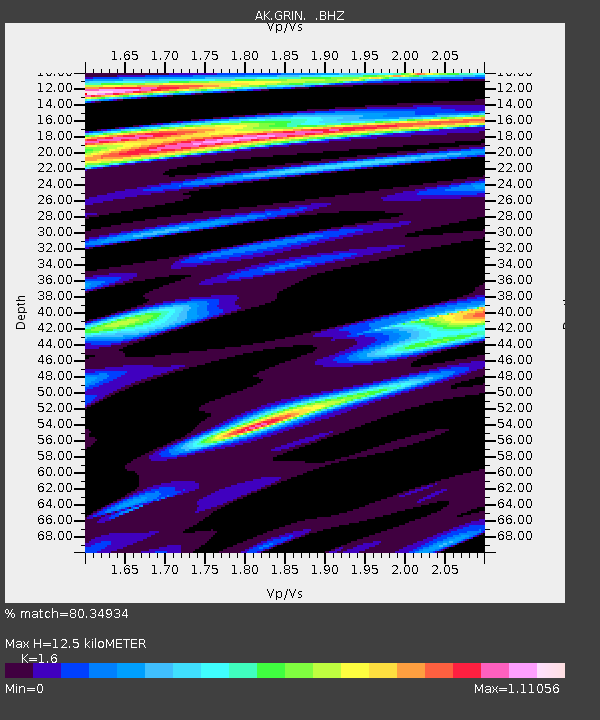
| Estimated Moho Depth: |
12.5 km |
| Estimated Crust Vp/Vs: |
1.60 |
| Assumed Crust Vp: |
6.566 km/s |
| Estimated Crust Vs: |
4.104 km/s |
| Estimated Crust Poisson's Ratio: |
0.18 |
|
| Radial Match: |
80.34934 % |
| Radial Bump: |
400 |
| Transverse Match: |
80.550896 % |
| Transverse Bump: |
400 |
| SOD ConfigId: |
769524 |
| Insert Time: |
2014-08-12 10:50:20.007 +0000 |
| GWidth: |
2.5 |
| Max Bumps: |
400 |
| Tol: |
0.001 |
|

Signal To Noise
| Channel | StoN | STA | LTA |
| AK:GRIN: :BHZ:20140729T10:55:01.428018Z | 23.784946 | 1.7545166E-6 | 7.376585E-8 |
| AK:GRIN: :BHN:20140729T10:55:01.428018Z | 8.842177 | 5.738522E-7 | 6.4899425E-8 |
| AK:GRIN: :BHE:20140729T10:55:01.428018Z | 9.336389 | 6.938713E-7 | 7.4319026E-8 |
| Arrivals |
| Ps | 1.2 SECOND |
| PpPs | 4.7 SECOND |
| PsPs/PpSs | 5.9 SECOND |


