You are here: Home > Network List > AK - Alaska Regional Network Stations List
> Station CUT Chulitna, AK, USA > Earthquake Result Viewer
CUT Chulitna, AK, USA - Earthquake Result Viewer
| Earthquake location: |
Oaxaca, Mexico |
| Earthquake latitude/longitude: |
17.8/-95.5 |
| Earthquake time(UTC): |
2014/07/29 (210) 10:46:15 GMT |
| Earthquake Depth: |
95 km |
| Earthquake Magnitude: |
6.3 MWP |
| Earthquake Catalog/Contributor: |
NEIC PDE/NEIC COMCAT |
|
| Network: |
AK Alaska Regional Network |
| Station: |
CUT Chulitna, AK, USA |
| Lat/Lon: |
62.41 N/150.26 W |
| Elevation: |
574 m |
|
| Distance: |
58.3 deg |
| Az: |
333.454 deg |
| Baz: |
113.911 deg |
| Ray Param: |
0.06266501 |
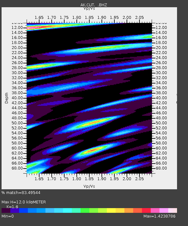
| Estimated Moho Depth: |
12.0 km |
| Estimated Crust Vp/Vs: |
1.60 |
| Assumed Crust Vp: |
6.438 km/s |
| Estimated Crust Vs: |
4.024 km/s |
| Estimated Crust Poisson's Ratio: |
0.18 |
|
| Radial Match: |
83.49544 % |
| Radial Bump: |
400 |
| Transverse Match: |
70.54549 % |
| Transverse Bump: |
400 |
| SOD ConfigId: |
769524 |
| Insert Time: |
2014-08-12 10:54:02.411 +0000 |
| GWidth: |
2.5 |
| Max Bumps: |
400 |
| Tol: |
0.001 |
|
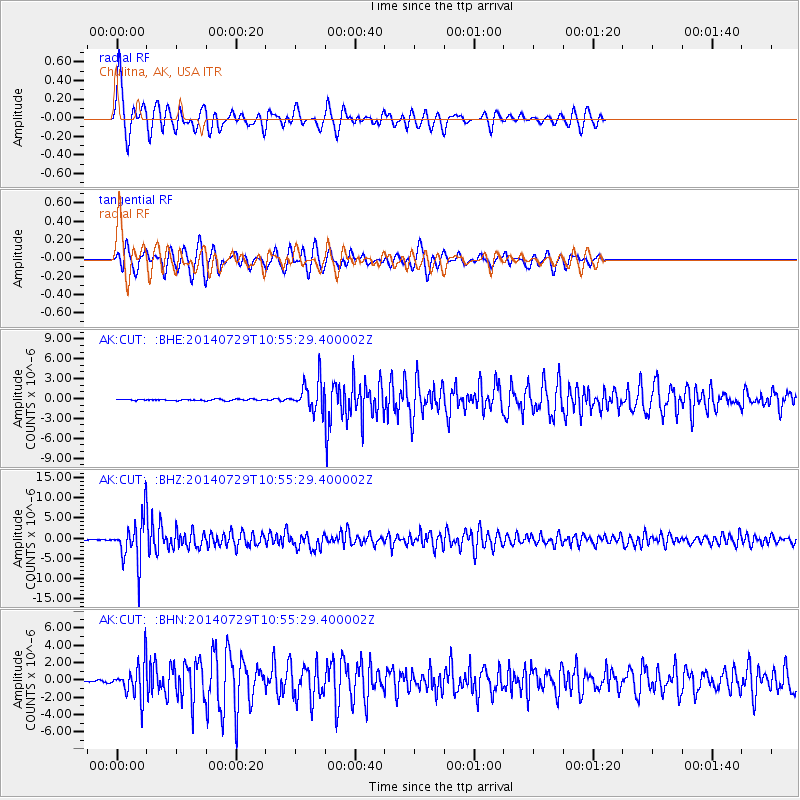
Signal To Noise
| Channel | StoN | STA | LTA |
| AK:CUT: :BHZ:20140729T10:55:29.400002Z | 90.129555 | 5.3837116E-6 | 5.973303E-8 |
| AK:CUT: :BHN:20140729T10:55:29.400002Z | 13.078801 | 1.9148185E-6 | 1.4640628E-7 |
| AK:CUT: :BHE:20140729T10:55:29.400002Z | 22.517784 | 2.2180354E-6 | 9.8501495E-8 |
| Arrivals |
| Ps | 1.2 SECOND |
| PpPs | 4.6 SECOND |
| PsPs/PpSs | 5.8 SECOND |


