You are here: Home > Network List > AT - Alaska Tsunami Warning Seismic System Stations List
> Station SIT Sitka, Alaska > Earthquake Result Viewer
SIT Sitka, Alaska - Earthquake Result Viewer
| Earthquake location: |
Oaxaca, Mexico |
| Earthquake latitude/longitude: |
17.8/-95.5 |
| Earthquake time(UTC): |
2014/07/29 (210) 10:46:15 GMT |
| Earthquake Depth: |
95 km |
| Earthquake Magnitude: |
6.3 MWP |
| Earthquake Catalog/Contributor: |
NEIC PDE/NEIC COMCAT |
|
| Network: |
AT Alaska Tsunami Warning Seismic System |
| Station: |
SIT Sitka, Alaska |
| Lat/Lon: |
57.06 N/135.32 W |
| Elevation: |
19 m |
|
| Distance: |
49.1 deg |
| Az: |
332.432 deg |
| Baz: |
126.217 deg |
| Ray Param: |
0.06862121 |
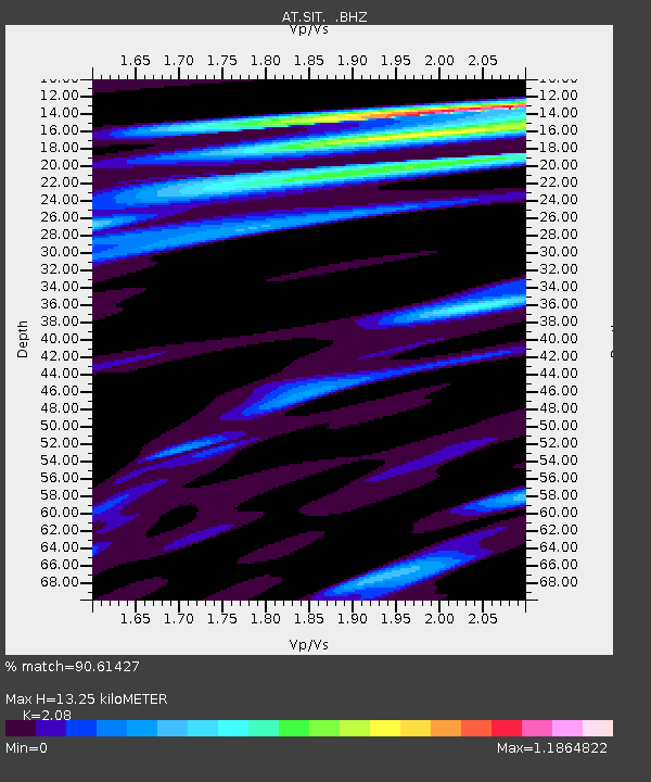
| Estimated Moho Depth: |
13.25 km |
| Estimated Crust Vp/Vs: |
2.08 |
| Assumed Crust Vp: |
6.472 km/s |
| Estimated Crust Vs: |
3.111 km/s |
| Estimated Crust Poisson's Ratio: |
0.35 |
|
| Radial Match: |
90.61427 % |
| Radial Bump: |
373 |
| Transverse Match: |
76.26018 % |
| Transverse Bump: |
400 |
| SOD ConfigId: |
769524 |
| Insert Time: |
2014-08-12 10:54:39.684 +0000 |
| GWidth: |
2.5 |
| Max Bumps: |
400 |
| Tol: |
0.001 |
|

Signal To Noise
| Channel | StoN | STA | LTA |
| AT:SIT: :BHZ:20140729T10:54:22.400002Z | 14.6254835 | 1.5596149E-6 | 1.0663681E-7 |
| AT:SIT: :BHN:20140729T10:54:22.400002Z | 8.080848 | 5.8892755E-7 | 7.287943E-8 |
| AT:SIT: :BHE:20140729T10:54:22.400002Z | 8.487935 | 6.398216E-7 | 7.538012E-8 |
| Arrivals |
| Ps | 2.3 SECOND |
| PpPs | 6.0 SECOND |
| PsPs/PpSs | 8.3 SECOND |


