You are here: Home > Network List > II - Global Seismograph Network (GSN - IRIS/IDA) Stations List
> Station TAU Hobart, Tasmania, Australia > Earthquake Result Viewer
TAU Hobart, Tasmania, Australia - Earthquake Result Viewer
| Earthquake location: |
New Ireland Region, P.N.G. |
| Earthquake latitude/longitude: |
-5.3/153.7 |
| Earthquake time(UTC): |
2003/01/10 (010) 13:11:56 GMT |
| Earthquake Depth: |
72 km |
| Earthquake Magnitude: |
5.9 MB, 6.7 MW, 6.6 MW |
| Earthquake Catalog/Contributor: |
WHDF/NEIC |
|
| Network: |
II Global Seismograph Network (GSN - IRIS/IDA) |
| Station: |
TAU Hobart, Tasmania, Australia |
| Lat/Lon: |
42.91 S/147.32 E |
| Elevation: |
132 m |
|
| Distance: |
37.9 deg |
| Az: |
187.644 deg |
| Baz: |
10.386 deg |
| Ray Param: |
0.07567122 |
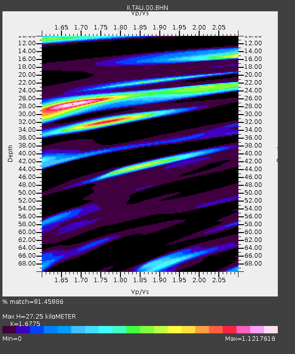
| Estimated Moho Depth: |
27.25 km |
| Estimated Crust Vp/Vs: |
1.68 |
| Assumed Crust Vp: |
6.477 km/s |
| Estimated Crust Vs: |
3.861 km/s |
| Estimated Crust Poisson's Ratio: |
0.22 |
|
| Radial Match: |
91.45986 % |
| Radial Bump: |
306 |
| Transverse Match: |
67.0683 % |
| Transverse Bump: |
400 |
| SOD ConfigId: |
4714 |
| Insert Time: |
2010-03-02 00:32:31.002 +0000 |
| GWidth: |
2.5 |
| Max Bumps: |
400 |
| Tol: |
0.001 |
|

Signal To Noise
| Channel | StoN | STA | LTA |
| II:TAU:00:BHN:20030110T13:18:36.493008Z | 3.0174546 | 1.5603076E-6 | 5.17094E-7 |
| II:TAU:00:BHE:20030110T13:18:36.493008Z | 2.3030026 | 9.851298E-7 | 4.277589E-7 |
| II:TAU:00:BHZ:20030110T13:18:36.493008Z | 8.939971 | 3.1442073E-6 | 3.5170217E-7 |
| Arrivals |
| Ps | 3.1 SECOND |
| PpPs | 10 SECOND |
| PsPs/PpSs | 13 SECOND |


