You are here: Home > Network List > TA - USArray Transportable Network (new EarthScope stations) Stations List
> Station I64A Boothbay, ME, USA > Earthquake Result Viewer
I64A Boothbay, ME, USA - Earthquake Result Viewer
| Earthquake location: |
Off East Coast Of Kamchatka |
| Earthquake latitude/longitude: |
53.0/160.0 |
| Earthquake time(UTC): |
2015/04/10 (100) 11:56:09 GMT |
| Earthquake Depth: |
55 km |
| Earthquake Magnitude: |
4.9 MW, 5.0 mb, 4.0 MS |
| Earthquake Catalog/Contributor: |
ISC/ISC |
|
| Network: |
TA USArray Transportable Network (new EarthScope stations) |
| Station: |
I64A Boothbay, ME, USA |
| Lat/Lon: |
43.92 N/69.63 W |
| Elevation: |
17 m |
|
| Distance: |
74.5 deg |
| Az: |
34.821 deg |
| Baz: |
331.453 deg |
| Ray Param: |
0.052181225 |
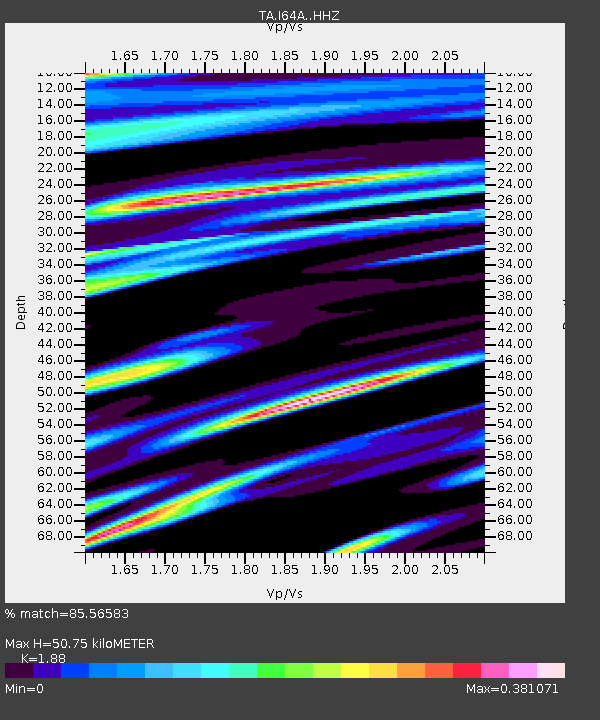
| Estimated Moho Depth: |
50.75 km |
| Estimated Crust Vp/Vs: |
1.88 |
| Assumed Crust Vp: |
6.419 km/s |
| Estimated Crust Vs: |
3.414 km/s |
| Estimated Crust Poisson's Ratio: |
0.30 |
|
| Radial Match: |
85.56583 % |
| Radial Bump: |
400 |
| Transverse Match: |
71.286736 % |
| Transverse Bump: |
400 |
| SOD ConfigId: |
7422571 |
| Insert Time: |
2019-04-18 03:25:25.723 +0000 |
| GWidth: |
2.5 |
| Max Bumps: |
400 |
| Tol: |
0.001 |
|
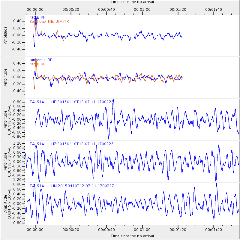
Signal To Noise
| Channel | StoN | STA | LTA |
| TA:I64A: :HHZ:20150410T12:07:11.170022Z | 1.466639 | 7.7825456E-7 | 5.306381E-7 |
| TA:I64A: :HHN:20150410T12:07:11.170022Z | 2.1435509 | 5.129978E-7 | 2.3932154E-7 |
| TA:I64A: :HHE:20150410T12:07:11.170022Z | 1.0016283 | 2.1219262E-7 | 2.1184766E-7 |
| Arrivals |
| Ps | 7.2 SECOND |
| PpPs | 22 SECOND |
| PsPs/PpSs | 29 SECOND |


