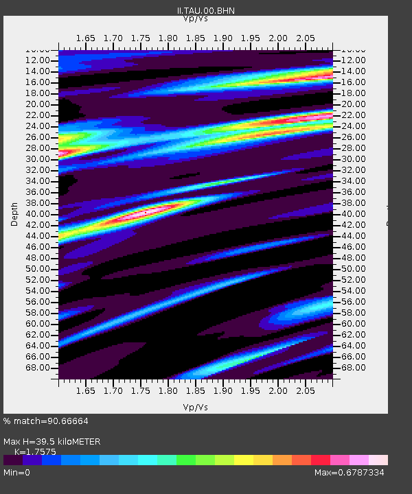
TAU Hobart, Tasmania, Australia - Earthquake Result Viewer

Earthquake location: Irian Jaya Region, Indonesia
Earthquake latitude/longitude: -3.6/135.5
Earthquake time(UTC): 2004/02/05 (036) 21:05:02 GMT
Earthquake Depth: 17 km
Earthquake Magnitude: 6.1 MB, 7.1 MS, 7.0 MW, 6.8 MW
Earthquake Catalog/Contributor: WHDF/NEIC
Network: II Global Seismograph Network (GSN - IRIS/IDA)
Station: TAU Hobart, Tasmania, Australia
Lat/Lon: 42.91 S/147.32 E
Elevation: 132 m
Distance: 40.5 deg
Az: 166.647 deg
Baz: 341.716 deg
Ray Param: 0.07434348
Estimated Moho Depth: 39.5 km
Estimated Crust Vp/Vs: 1.76
Assumed Crust Vp: 6.477 km/s
Estimated Crust Vs: 3.685 km/s
Estimated Crust Poisson's Ratio: 0.26
Radial Match: 90.66664 %
Radial Bump: 333
Transverse Match: 50.85564 %
Transverse Bump: 400
SOD ConfigId: 2459
Insert Time: 2010-03-02 00:32:42.355 +0000
GWidth: 2.5
Max Bumps: 400
Tol: 0.001

Signal To Noise

ChannelStoNSTALTA
II:TAU:00:BHN:20040205T21:12:10.066013Z2.2432561.4703414E-66.5544964E-7
II:TAU:00:BHE:20040205T21:12:10.066013Z1.34779374.4658336E-73.31344E-7
II:TAU:00:BHZ:20040205T21:12:10.066013Z3.93684272.685306E-66.8209636E-7
Arrivals
Ps5.0 SECOND
PpPs16 SECOND
PsPs/PpSs21 SECOND