You are here: Home > Network List > CN - Canadian National Seismograph Network Stations List
> Station DIB DAWSON INLET, BC > Earthquake Result Viewer
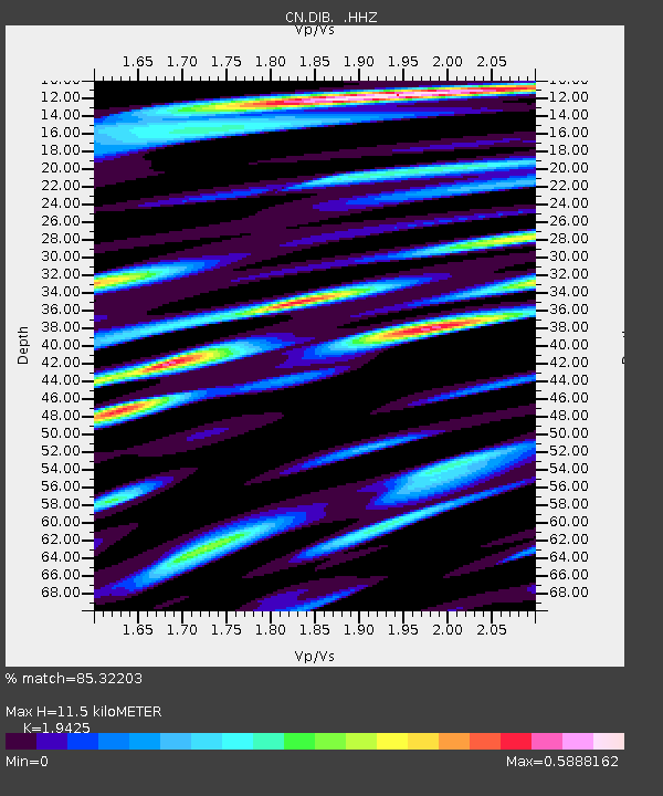
DIB DAWSON INLET, BC - Earthquake Result Viewer
| Earthquake location: |
Oaxaca, Mexico |
| Earthquake latitude/longitude: |
17.8/-95.5 |
| Earthquake time(UTC): |
2014/07/29 (210) 10:46:15 GMT |
| Earthquake Depth: |
95 km |
| Earthquake Magnitude: |
6.3 MWP |
| Earthquake Catalog/Contributor: |
NEIC PDE/NEIC COMCAT |
|
| Network: |
CN Canadian National Seismograph Network |
| Station: |
DIB DAWSON INLET, BC |
| Lat/Lon: |
53.20 N/132.48 W |
| Elevation: |
68 m |
|
| Distance: |
45.5 deg |
| Az: |
329.522 deg |
| Baz: |
126.574 deg |
| Ray Param: |
0.07093044 |
| Estimated Moho Depth: |
11.5 km |
| Estimated Crust Vp/Vs: |
1.94 |
| Assumed Crust Vp: |
6.183 km/s |
| Estimated Crust Vs: |
3.183 km/s |
| Estimated Crust Poisson's Ratio: |
0.32 |
|
| Radial Match: |
85.32203 % |
| Radial Bump: |
400 |
| Transverse Match: |
75.80167 % |
| Transverse Bump: |
400 |
| SOD ConfigId: |
769524 |
| Insert Time: |
2014-08-12 11:00:07.107 +0000 |
| GWidth: |
2.5 |
| Max Bumps: |
400 |
| Tol: |
0.001 |
|

Signal To Noise
| Channel | StoN | STA | LTA |
| CN:DIB: :HHZ:20140729T10:53:54.440011Z | 15.12887 | 2.0221892E-6 | 1.3366426E-7 |
| CN:DIB: :HHN:20140729T10:53:54.440011Z | 5.1689262 | 6.3191015E-7 | 1.2225172E-7 |
| CN:DIB: :HHE:20140729T10:53:54.440011Z | 5.774885 | 8.4204845E-7 | 1.4581215E-7 |
| Arrivals |
| Ps | 1.8 SECOND |
| PpPs | 5.2 SECOND |
| PsPs/PpSs | 7.0 SECOND |


