You are here: Home > Network List > II - Global Seismograph Network (GSN - IRIS/IDA) Stations List
> Station TAU Hobart, Tasmania, Australia > Earthquake Result Viewer
TAU Hobart, Tasmania, Australia - Earthquake Result Viewer
| Earthquake location: |
Banda Sea |
| Earthquake latitude/longitude: |
-6.5/129.9 |
| Earthquake time(UTC): |
2005/03/02 (061) 10:42:12 GMT |
| Earthquake Depth: |
202 km |
| Earthquake Magnitude: |
7.0 MB, 7.1 MW, 7.1 MW |
| Earthquake Catalog/Contributor: |
WHDF/NEIC |
|
| Network: |
II Global Seismograph Network (GSN - IRIS/IDA) |
| Station: |
TAU Hobart, Tasmania, Australia |
| Lat/Lon: |
42.91 S/147.32 E |
| Elevation: |
132 m |
|
| Distance: |
39.4 deg |
| Az: |
159.742 deg |
| Baz: |
332.079 deg |
| Ray Param: |
0.07427228 |
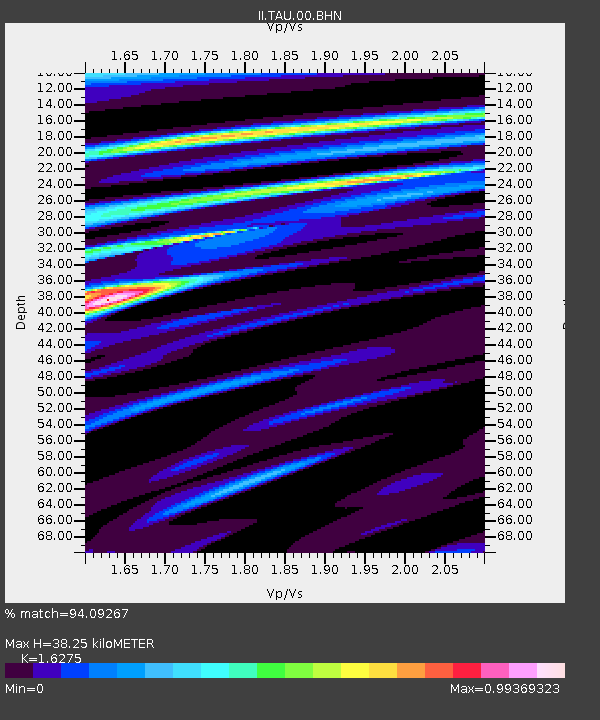
| Estimated Moho Depth: |
38.25 km |
| Estimated Crust Vp/Vs: |
1.63 |
| Assumed Crust Vp: |
6.477 km/s |
| Estimated Crust Vs: |
3.98 km/s |
| Estimated Crust Poisson's Ratio: |
0.20 |
|
| Radial Match: |
94.09267 % |
| Radial Bump: |
400 |
| Transverse Match: |
71.91962 % |
| Transverse Bump: |
400 |
| SOD ConfigId: |
2455 |
| Insert Time: |
2010-03-02 00:32:53.653 +0000 |
| GWidth: |
2.5 |
| Max Bumps: |
400 |
| Tol: |
0.001 |
|
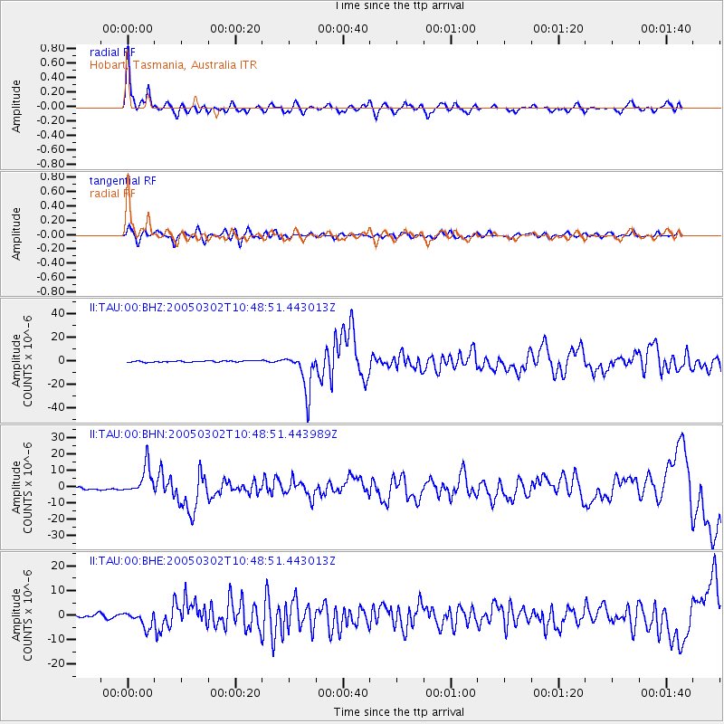
Signal To Noise
| Channel | StoN | STA | LTA |
| II:TAU:00:BHN:20050302T10:48:51.443989Z | 13.474211 | 8.9638925E-6 | 6.652629E-7 |
| II:TAU:00:BHE:20050302T10:48:51.443013Z | 5.573909 | 3.3096874E-6 | 5.9378215E-7 |
| II:TAU:00:BHZ:20050302T10:48:51.443013Z | 29.93901 | 1.7056913E-5 | 5.6972203E-7 |
| Arrivals |
| Ps | 4.0 SECOND |
| PpPs | 14 SECOND |
| PsPs/PpSs | 18 SECOND |


