You are here: Home > Network List > II - Global Seismograph Network (GSN - IRIS/IDA) Stations List
> Station TAU Hobart, Tasmania, Australia > Earthquake Result Viewer
TAU Hobart, Tasmania, Australia - Earthquake Result Viewer
| Earthquake location: |
Philippine Islands Region |
| Earthquake latitude/longitude: |
13.4/125.6 |
| Earthquake time(UTC): |
2008/03/03 (063) 14:11:14 GMT |
| Earthquake Depth: |
24 km |
| Earthquake Magnitude: |
6.4 MB, 6.9 MW, 6.8 MW |
| Earthquake Catalog/Contributor: |
WHDF/NEIC |
|
| Network: |
II Global Seismograph Network (GSN - IRIS/IDA) |
| Station: |
TAU Hobart, Tasmania, Australia |
| Lat/Lon: |
42.91 S/147.32 E |
| Elevation: |
132 m |
|
| Distance: |
59.4 deg |
| Az: |
161.614 deg |
| Baz: |
335.3 deg |
| Ray Param: |
0.06216959 |
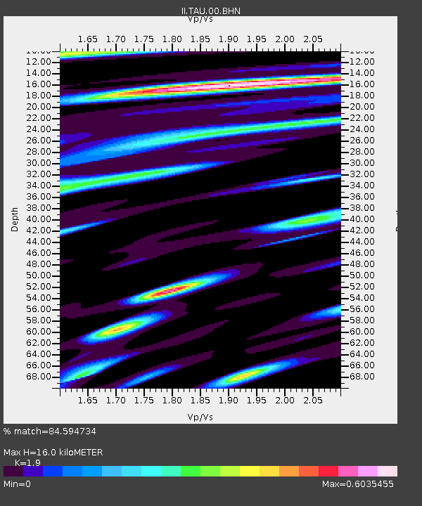
| Estimated Moho Depth: |
16.0 km |
| Estimated Crust Vp/Vs: |
1.90 |
| Assumed Crust Vp: |
6.477 km/s |
| Estimated Crust Vs: |
3.409 km/s |
| Estimated Crust Poisson's Ratio: |
0.31 |
|
| Radial Match: |
84.594734 % |
| Radial Bump: |
400 |
| Transverse Match: |
73.1034 % |
| Transverse Bump: |
400 |
| SOD ConfigId: |
2564 |
| Insert Time: |
2010-03-02 00:33:08.812 +0000 |
| GWidth: |
2.5 |
| Max Bumps: |
400 |
| Tol: |
0.001 |
|

Signal To Noise
| Channel | StoN | STA | LTA |
| II:TAU:00:BHN:20080303T14:20:44.177007Z | 1.734333 | 7.740202E-7 | 4.4629272E-7 |
| II:TAU:00:BHE:20080303T14:20:44.177007Z | 0.53209937 | 3.5770222E-7 | 6.72247E-7 |
| II:TAU:00:BHZ:20080303T14:20:44.177007Z | 2.49519 | 1.8700466E-6 | 7.4946064E-7 |
| Arrivals |
| Ps | 2.3 SECOND |
| PpPs | 6.8 SECOND |
| PsPs/PpSs | 9.2 SECOND |


