You are here: Home > Network List > II - Global Seismograph Network (GSN - IRIS/IDA) Stations List
> Station TAU Hobart, Tasmania, Australia > Earthquake Result Viewer
TAU Hobart, Tasmania, Australia - Earthquake Result Viewer

| Earthquake location: |
Solomon Islands |
| Earthquake latitude/longitude: |
-6.5/154.9 |
| Earthquake time(UTC): |
1994/04/18 (108) 17:29:56 GMT |
| Earthquake Depth: |
43 km |
| Earthquake Magnitude: |
6.6 MB, 6.7 MS, 6.8 UNKNOWN, 6.7 MW |
| Earthquake Catalog/Contributor: |
WHDF/NEIC |
|
| Network: |
II Global Seismograph Network (GSN - IRIS/IDA) |
| Station: |
TAU Hobart, Tasmania, Australia |
| Lat/Lon: |
42.91 S/147.32 E |
| Elevation: |
132 m |
|
| Distance: |
36.9 deg |
| Az: |
189.31 deg |
| Baz: |
12.638 deg |
| Ray Param: |
0.07633566 |
| Estimated Moho Depth: |
22.25 km |
| Estimated Crust Vp/Vs: |
1.74 |
| Assumed Crust Vp: |
6.477 km/s |
| Estimated Crust Vs: |
3.717 km/s |
| Estimated Crust Poisson's Ratio: |
0.25 |
|
| Radial Match: |
81.341896 % |
| Radial Bump: |
400 |
| Transverse Match: |
50.308792 % |
| Transverse Bump: |
400 |
| SOD ConfigId: |
61242 |
| Insert Time: |
2010-03-02 00:33:17.643 +0000 |
| GWidth: |
2.5 |
| Max Bumps: |
400 |
| Tol: |
0.001 |
|
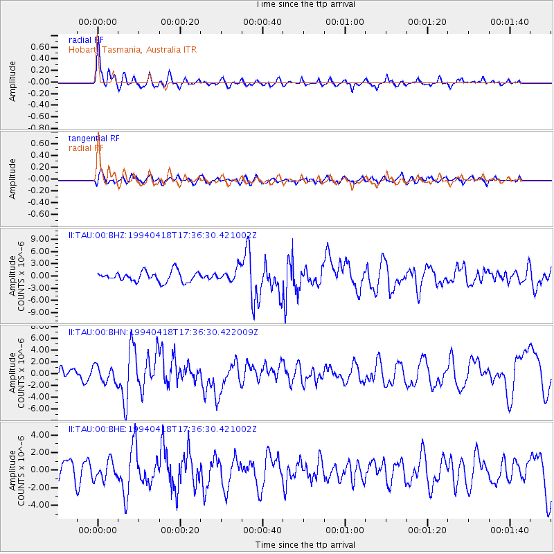
Signal To Noise
| Channel | StoN | STA | LTA |
| II:TAU:00:BHN:19940418T17:36:30.422009Z | 1.3427539 | 1.3965409E-6 | 1.0400572E-6 |
| II:TAU:00:BHE:19940418T17:36:30.421002Z | 0.7629931 | 1.0436223E-6 | 1.3678005E-6 |
| II:TAU:00:BHZ:19940418T17:36:30.421002Z | 1.3265742 | 1.6543901E-6 | 1.2471146E-6 |
| Arrivals |
| Ps | 2.8 SECOND |
| PpPs | 8.7 SECOND |
| PsPs/PpSs | 11 SECOND |


