You are here: Home > Network List > NE - New England Seismic Network Stations List
> Station EMMW Machias, ME, USA > Earthquake Result Viewer
EMMW Machias, ME, USA - Earthquake Result Viewer
| Earthquake location: |
Oaxaca, Mexico |
| Earthquake latitude/longitude: |
17.8/-95.5 |
| Earthquake time(UTC): |
2014/07/29 (210) 10:46:15 GMT |
| Earthquake Depth: |
95 km |
| Earthquake Magnitude: |
6.3 MWP |
| Earthquake Catalog/Contributor: |
NEIC PDE/NEIC COMCAT |
|
| Network: |
NE New England Seismic Network |
| Station: |
EMMW Machias, ME, USA |
| Lat/Lon: |
44.71 N/67.46 W |
| Elevation: |
35 m |
|
| Distance: |
35.6 deg |
| Az: |
35.167 deg |
| Baz: |
230.297 deg |
| Ray Param: |
0.07681749 |
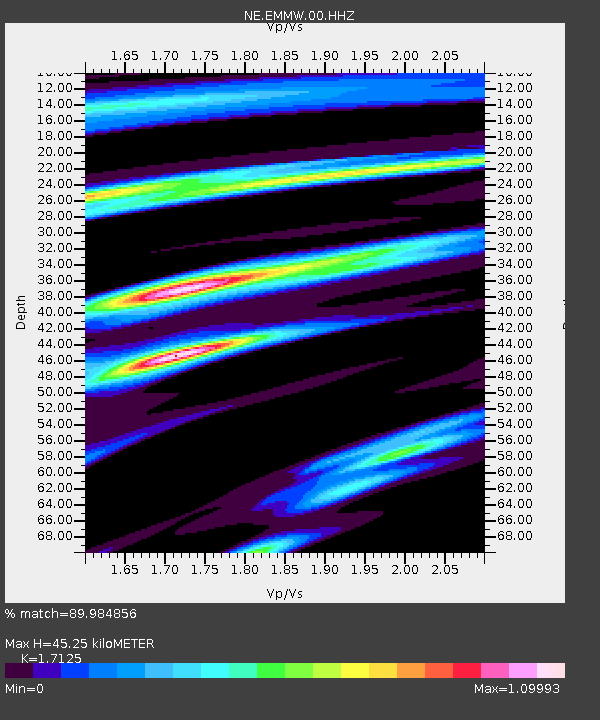
| Estimated Moho Depth: |
45.25 km |
| Estimated Crust Vp/Vs: |
1.71 |
| Assumed Crust Vp: |
6.419 km/s |
| Estimated Crust Vs: |
3.748 km/s |
| Estimated Crust Poisson's Ratio: |
0.24 |
|
| Radial Match: |
89.984856 % |
| Radial Bump: |
324 |
| Transverse Match: |
79.17875 % |
| Transverse Bump: |
400 |
| SOD ConfigId: |
769524 |
| Insert Time: |
2014-08-12 11:11:47.055 +0000 |
| GWidth: |
2.5 |
| Max Bumps: |
400 |
| Tol: |
0.001 |
|

Signal To Noise
| Channel | StoN | STA | LTA |
| NE:EMMW:00:HHZ:20140729T10:52:33.534005Z | 4.3354278 | 9.85505E-7 | 2.2731437E-7 |
| NE:EMMW:00:HH1:20140729T10:52:33.534005Z | 3.1983721 | 4.826617E-7 | 1.5090855E-7 |
| NE:EMMW:00:HH2:20140729T10:52:33.534005Z | 3.3520796 | 5.1804955E-7 | 1.545457E-7 |
| Arrivals |
| Ps | 5.4 SECOND |
| PpPs | 18 SECOND |
| PsPs/PpSs | 23 SECOND |


