You are here: Home > Network List > TA - USArray Transportable Network (new EarthScope stations) Stations List
> Station B05D Stanwood, WA, USA > Earthquake Result Viewer
B05D Stanwood, WA, USA - Earthquake Result Viewer
| Earthquake location: |
Oaxaca, Mexico |
| Earthquake latitude/longitude: |
17.8/-95.5 |
| Earthquake time(UTC): |
2014/07/29 (210) 10:46:15 GMT |
| Earthquake Depth: |
95 km |
| Earthquake Magnitude: |
6.3 MWP |
| Earthquake Catalog/Contributor: |
NEIC PDE/NEIC COMCAT |
|
| Network: |
TA USArray Transportable Network (new EarthScope stations) |
| Station: |
B05D Stanwood, WA, USA |
| Lat/Lon: |
48.26 N/122.10 W |
| Elevation: |
153 m |
|
| Distance: |
37.3 deg |
| Az: |
330.424 deg |
| Baz: |
135.284 deg |
| Ray Param: |
0.07591995 |
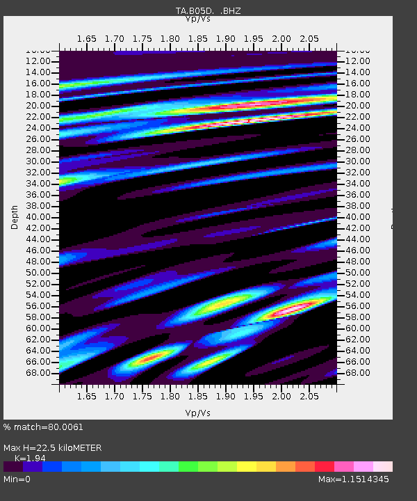
| Estimated Moho Depth: |
22.5 km |
| Estimated Crust Vp/Vs: |
1.94 |
| Assumed Crust Vp: |
6.566 km/s |
| Estimated Crust Vs: |
3.385 km/s |
| Estimated Crust Poisson's Ratio: |
0.32 |
|
| Radial Match: |
80.0061 % |
| Radial Bump: |
400 |
| Transverse Match: |
69.147736 % |
| Transverse Bump: |
400 |
| SOD ConfigId: |
769524 |
| Insert Time: |
2014-08-12 11:15:39.102 +0000 |
| GWidth: |
2.5 |
| Max Bumps: |
400 |
| Tol: |
0.001 |
|

Signal To Noise
| Channel | StoN | STA | LTA |
| TA:B05D: :BHZ:20140729T10:52:47.475015Z | 30.39806 | 1.6319441E-6 | 5.36858E-8 |
| TA:B05D: :BHN:20140729T10:52:47.475015Z | 16.824165 | 6.927153E-7 | 4.1173827E-8 |
| TA:B05D: :BHE:20140729T10:52:47.475015Z | 22.732796 | 7.3599455E-7 | 3.2375894E-8 |
| Arrivals |
| Ps | 3.5 SECOND |
| PpPs | 9.4 SECOND |
| PsPs/PpSs | 13 SECOND |


