You are here: Home > Network List > US - United States National Seismic Network Stations List
> Station DUG Dugway, Tooele County, Utah, USA > Earthquake Result Viewer
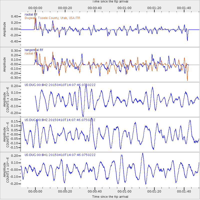
DUG Dugway, Tooele County, Utah, USA - Earthquake Result Viewer
*The percent match for this event was below the threshold and hence no stack was calculated.
| Earthquake location: |
Kuril Islands |
| Earthquake latitude/longitude: |
47.1/150.8 |
| Earthquake time(UTC): |
2015/04/10 (100) 13:57:53 GMT |
| Earthquake Depth: |
200 km |
| Earthquake Magnitude: |
4.1 mb, 3.9 mb |
| Earthquake Catalog/Contributor: |
ISC/ISC |
|
| Network: |
US United States National Seismic Network |
| Station: |
DUG Dugway, Tooele County, Utah, USA |
| Lat/Lon: |
40.19 N/112.81 W |
| Elevation: |
1477 m |
|
| Distance: |
65.7 deg |
| Az: |
56.617 deg |
| Baz: |
311.851 deg |
| Ray Param: |
$rayparam |
*The percent match for this event was below the threshold and hence was not used in the summary stack. |
|
| Radial Match: |
34.829254 % |
| Radial Bump: |
371 |
| Transverse Match: |
41.98536 % |
| Transverse Bump: |
333 |
| SOD ConfigId: |
7422571 |
| Insert Time: |
2019-04-18 03:33:51.740 +0000 |
| GWidth: |
2.5 |
| Max Bumps: |
400 |
| Tol: |
0.001 |
|
Signal To Noise
| Channel | StoN | STA | LTA |
| US:DUG:00:BHZ:20150410T14:07:46.075022Z | 1.9194795 | 9.9163515E-8 | 5.166167E-8 |
| US:DUG:00:BH1:20150410T14:07:46.075022Z | 0.65358293 | 4.545195E-8 | 6.954275E-8 |
| US:DUG:00:BH2:20150410T14:07:46.075022Z | 1.9627233 | 1.6067652E-7 | 8.186407E-8 |
| Arrivals |
| Ps | |
| PpPs | |
| PsPs/PpSs | |


