You are here: Home > Network List > US - United States National Seismic Network Stations List
> Station GLMI Grayling, Michigan, USA > Earthquake Result Viewer
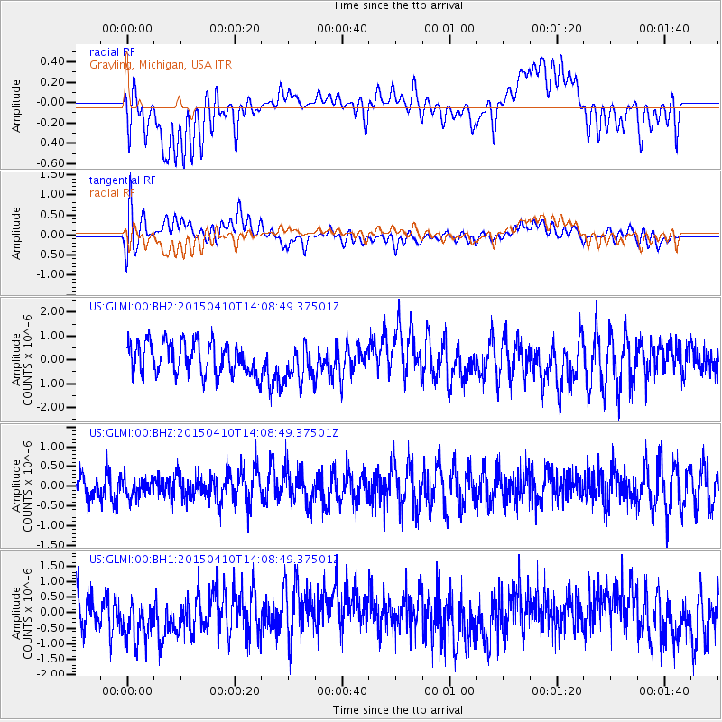
GLMI Grayling, Michigan, USA - Earthquake Result Viewer
*The percent match for this event was below the threshold and hence no stack was calculated.
| Earthquake location: |
Kuril Islands |
| Earthquake latitude/longitude: |
47.1/150.8 |
| Earthquake time(UTC): |
2015/04/10 (100) 13:57:53 GMT |
| Earthquake Depth: |
200 km |
| Earthquake Magnitude: |
4.1 mb, 3.9 mb |
| Earthquake Catalog/Contributor: |
ISC/ISC |
|
| Network: |
US United States National Seismic Network |
| Station: |
GLMI Grayling, Michigan, USA |
| Lat/Lon: |
44.82 N/84.62 W |
| Elevation: |
387 m |
|
| Distance: |
76.3 deg |
| Az: |
37.083 deg |
| Baz: |
324.622 deg |
| Ray Param: |
$rayparam |
*The percent match for this event was below the threshold and hence was not used in the summary stack. |
|
| Radial Match: |
55.05609 % |
| Radial Bump: |
400 |
| Transverse Match: |
61.040546 % |
| Transverse Bump: |
400 |
| SOD ConfigId: |
7422571 |
| Insert Time: |
2019-04-18 03:33:53.148 +0000 |
| GWidth: |
2.5 |
| Max Bumps: |
400 |
| Tol: |
0.001 |
|
Signal To Noise
| Channel | StoN | STA | LTA |
| US:GLMI:00:BHZ:20150410T14:08:49.37501Z | 0.598995 | 2.3191211E-7 | 3.871687E-7 |
| US:GLMI:00:BH1:20150410T14:08:49.37501Z | 1.4075041 | 8.8989674E-7 | 6.322516E-7 |
| US:GLMI:00:BH2:20150410T14:08:49.37501Z | 1.1664386 | 7.6372555E-7 | 6.547499E-7 |
| Arrivals |
| Ps | |
| PpPs | |
| PsPs/PpSs | |


