You are here: Home > Network List > II - Global Seismograph Network (GSN - IRIS/IDA) Stations List
> Station TAU Hobart, Tasmania, Australia > Earthquake Result Viewer
TAU Hobart, Tasmania, Australia - Earthquake Result Viewer
| Earthquake location: |
Vanuatu Islands |
| Earthquake latitude/longitude: |
-16.6/167.4 |
| Earthquake time(UTC): |
1994/07/13 (194) 02:43:46 GMT |
| Earthquake Depth: |
33 km |
| Earthquake Magnitude: |
5.6 MB |
| Earthquake Catalog/Contributor: |
WHDF/NEIC |
|
| Network: |
II Global Seismograph Network (GSN - IRIS/IDA) |
| Station: |
TAU Hobart, Tasmania, Australia |
| Lat/Lon: |
42.91 S/147.32 E |
| Elevation: |
132 m |
|
| Distance: |
31.3 deg |
| Az: |
208.941 deg |
| Baz: |
39.176 deg |
| Ray Param: |
0.07906308 |
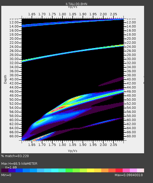
| Estimated Moho Depth: |
68.5 km |
| Estimated Crust Vp/Vs: |
1.69 |
| Assumed Crust Vp: |
6.477 km/s |
| Estimated Crust Vs: |
3.832 km/s |
| Estimated Crust Poisson's Ratio: |
0.23 |
|
| Radial Match: |
83.228 % |
| Radial Bump: |
400 |
| Transverse Match: |
45.039783 % |
| Transverse Bump: |
277 |
| SOD ConfigId: |
17000 |
| Insert Time: |
2010-03-02 00:33:37.414 +0000 |
| GWidth: |
2.5 |
| Max Bumps: |
400 |
| Tol: |
0.001 |
|
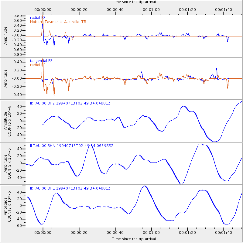
Signal To Noise
| Channel | StoN | STA | LTA |
| II:TAU:00:BHN:19940713T02:49:34.065985Z | 0.8723079 | 1.2562838E-5 | 1.4401839E-5 |
| II:TAU:00:BHE:19940713T02:49:34.04801Z | 3.0907981 | 4.2213684E-5 | 1.3657858E-5 |
| II:TAU:00:BHZ:19940713T02:49:34.04801Z | 0.36067185 | 3.995641E-6 | 1.1078328E-5 |
| Arrivals |
| Ps | 7.9 SECOND |
| PpPs | 26 SECOND |
| PsPs/PpSs | 34 SECOND |


