You are here: Home > Network List > TA - USArray Transportable Network (new EarthScope stations) Stations List
> Station F51A Arnstein, ON, CAN > Earthquake Result Viewer
F51A Arnstein, ON, CAN - Earthquake Result Viewer

| Earthquake location: |
Oaxaca, Mexico |
| Earthquake latitude/longitude: |
17.8/-95.5 |
| Earthquake time(UTC): |
2014/07/29 (210) 10:46:15 GMT |
| Earthquake Depth: |
95 km |
| Earthquake Magnitude: |
6.3 MWP |
| Earthquake Catalog/Contributor: |
NEIC PDE/NEIC COMCAT |
|
| Network: |
TA USArray Transportable Network (new EarthScope stations) |
| Station: |
F51A Arnstein, ON, CAN |
| Lat/Lon: |
45.93 N/79.92 W |
| Elevation: |
239 m |
|
| Distance: |
30.9 deg |
| Az: |
21.474 deg |
| Baz: |
209.973 deg |
| Ray Param: |
0.07906588 |
| Estimated Moho Depth: |
50.25 km |
| Estimated Crust Vp/Vs: |
1.60 |
| Assumed Crust Vp: |
6.577 km/s |
| Estimated Crust Vs: |
4.111 km/s |
| Estimated Crust Poisson's Ratio: |
0.18 |
|
| Radial Match: |
90.065895 % |
| Radial Bump: |
400 |
| Transverse Match: |
66.852005 % |
| Transverse Bump: |
400 |
| SOD ConfigId: |
769524 |
| Insert Time: |
2014-08-12 11:19:03.614 +0000 |
| GWidth: |
2.5 |
| Max Bumps: |
400 |
| Tol: |
0.001 |
|
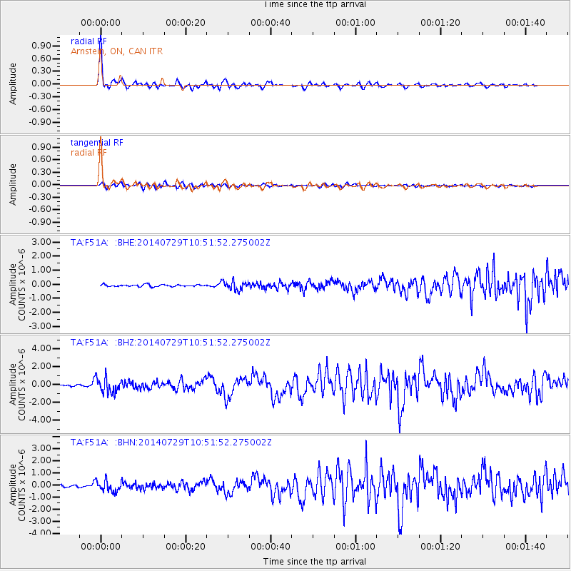
Signal To Noise
| Channel | StoN | STA | LTA |
| TA:F51A: :BHZ:20140729T10:51:52.275002Z | 9.711592 | 8.226644E-7 | 8.4709534E-8 |
| TA:F51A: :BHN:20140729T10:51:52.275002Z | 5.6717544 | 4.4280964E-7 | 7.807278E-8 |
| TA:F51A: :BHE:20140729T10:51:52.275002Z | 4.4503574 | 2.999295E-7 | 6.739447E-8 |
| Arrivals |
| Ps | 5.0 SECOND |
| PpPs | 18 SECOND |
| PsPs/PpSs | 23 SECOND |


