You are here: Home > Network List > II - Global Seismograph Network (GSN - IRIS/IDA) Stations List
> Station TAU Hobart, Tasmania, Australia > Earthquake Result Viewer
TAU Hobart, Tasmania, Australia - Earthquake Result Viewer
| Earthquake location: |
Solomon Islands |
| Earthquake latitude/longitude: |
-5.8/154.3 |
| Earthquake time(UTC): |
1995/08/16 (228) 23:10:28 GMT |
| Earthquake Depth: |
74 km |
| Earthquake Magnitude: |
6.1 MB, 7.2 MS, 7.2 UNKNOWN, 7.2 MW |
| Earthquake Catalog/Contributor: |
WHDF/NEIC |
|
| Network: |
II Global Seismograph Network (GSN - IRIS/IDA) |
| Station: |
TAU Hobart, Tasmania, Australia |
| Lat/Lon: |
42.91 S/147.32 E |
| Elevation: |
132 m |
|
| Distance: |
37.5 deg |
| Az: |
188.383 deg |
| Baz: |
11.388 deg |
| Ray Param: |
0.0758854 |
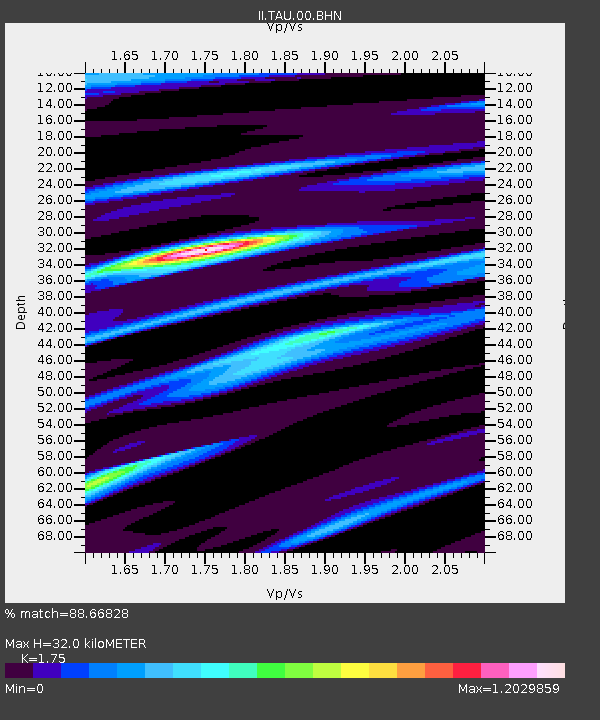
| Estimated Moho Depth: |
32.0 km |
| Estimated Crust Vp/Vs: |
1.75 |
| Assumed Crust Vp: |
6.477 km/s |
| Estimated Crust Vs: |
3.701 km/s |
| Estimated Crust Poisson's Ratio: |
0.26 |
|
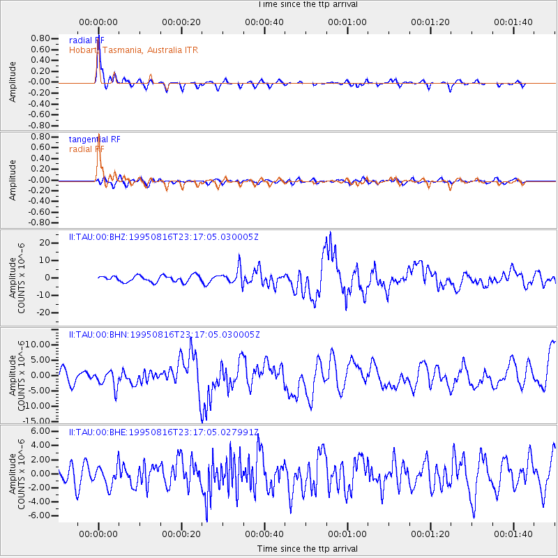
| Radial Match: |
88.66828 % |
| Radial Bump: |
354 |
| Transverse Match: |
60.06752 % |
| Transverse Bump: |
400 |
| SOD ConfigId: |
6273 |
| Insert Time: |
2010-03-02 00:33:51.181 +0000 |
| GWidth: |
2.5 |
| Max Bumps: |
400 |
| Tol: |
0.001 |
|
Signal To Noise
| Channel | StoN | STA | LTA |
| II:TAU:00:BHN:19950816T23:17:05.030005Z | 1.6697289 | 2.6776497E-6 | 1.6036433E-6 |
| II:TAU:00:BHE:19950816T23:17:05.027991Z | 0.8456459 | 1.5033338E-6 | 1.7777343E-6 |
| II:TAU:00:BHZ:19950816T23:17:05.030005Z | 2.4564846 | 4.4087838E-6 | 1.7947533E-6 |
| Arrivals |
| Ps | 4.0 SECOND |
| PpPs | 13 SECOND |
| PsPs/PpSs | 17 SECOND |


