You are here: Home > Network List > II - Global Seismograph Network (GSN - IRIS/IDA) Stations List
> Station TAU Hobart, Tasmania, Australia > Earthquake Result Viewer
TAU Hobart, Tasmania, Australia - Earthquake Result Viewer
| Earthquake location: |
Vanuatu Islands |
| Earthquake latitude/longitude: |
-13.5/167.1 |
| Earthquake time(UTC): |
1996/06/10 (162) 01:04:46 GMT |
| Earthquake Depth: |
200 km |
| Earthquake Magnitude: |
5.8 MB, 5.9 MS, 6.7 UNKNOWN, 6.0 MS |
| Earthquake Catalog/Contributor: |
WHDF/NEIC |
|
| Network: |
II Global Seismograph Network (GSN - IRIS/IDA) |
| Station: |
TAU Hobart, Tasmania, Australia |
| Lat/Lon: |
42.91 S/147.32 E |
| Elevation: |
132 m |
|
| Distance: |
33.9 deg |
| Az: |
206.48 deg |
| Baz: |
36.185 deg |
| Ray Param: |
0.07728401 |
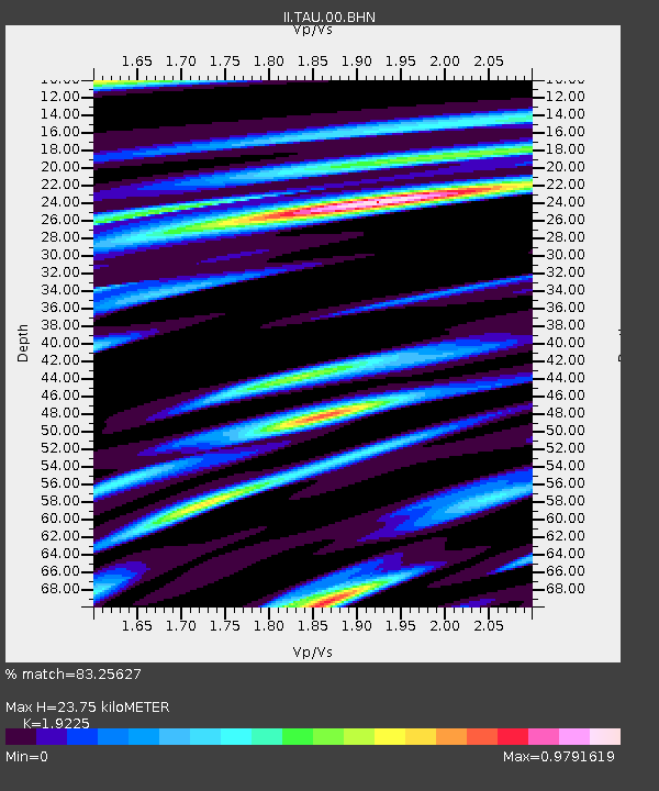
| Estimated Moho Depth: |
23.75 km |
| Estimated Crust Vp/Vs: |
1.92 |
| Assumed Crust Vp: |
6.477 km/s |
| Estimated Crust Vs: |
3.369 km/s |
| Estimated Crust Poisson's Ratio: |
0.31 |
|
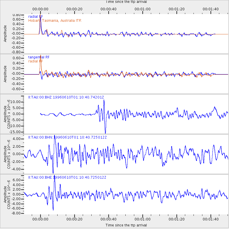
| Radial Match: |
83.25627 % |
| Radial Bump: |
374 |
| Transverse Match: |
69.49729 % |
| Transverse Bump: |
400 |
| SOD ConfigId: |
6273 |
| Insert Time: |
2010-03-02 00:33:57.940 +0000 |
| GWidth: |
2.5 |
| Max Bumps: |
400 |
| Tol: |
0.001 |
|
Signal To Noise
| Channel | StoN | STA | LTA |
| II:TAU:00:BHN:19960610T01:10:40.725012Z | 2.808983 | 1.312376E-6 | 4.6720677E-7 |
| II:TAU:00:BHE:19960610T01:10:40.725012Z | 3.4033914 | 1.4337901E-6 | 4.2128275E-7 |
| II:TAU:00:BHZ:19960610T01:10:40.74201Z | 4.058805 | 2.5902384E-6 | 6.381776E-7 |
| Arrivals |
| Ps | 3.6 SECOND |
| PpPs | 10.0 SECOND |
| PsPs/PpSs | 14 SECOND |


