You are here: Home > Network List > TA - USArray Transportable Network (new EarthScope stations) Stations List
> Station G59A Clarenceville, QC, USA > Earthquake Result Viewer
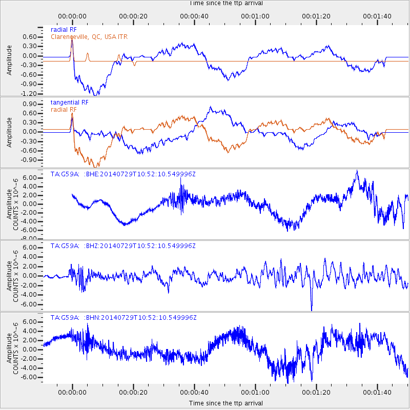
G59A Clarenceville, QC, USA - Earthquake Result Viewer
*The percent match for this event was below the threshold and hence no stack was calculated.
| Earthquake location: |
Oaxaca, Mexico |
| Earthquake latitude/longitude: |
17.8/-95.5 |
| Earthquake time(UTC): |
2014/07/29 (210) 10:46:15 GMT |
| Earthquake Depth: |
95 km |
| Earthquake Magnitude: |
6.3 MWP |
| Earthquake Catalog/Contributor: |
NEIC PDE/NEIC COMCAT |
|
| Network: |
TA USArray Transportable Network (new EarthScope stations) |
| Station: |
G59A Clarenceville, QC, USA |
| Lat/Lon: |
45.08 N/73.18 W |
| Elevation: |
36 m |
|
| Distance: |
33.0 deg |
| Az: |
29.676 deg |
| Baz: |
221.73 deg |
| Ray Param: |
$rayparam |
*The percent match for this event was below the threshold and hence was not used in the summary stack. |
|
| Radial Match: |
55.290928 % |
| Radial Bump: |
400 |
| Transverse Match: |
38.612053 % |
| Transverse Bump: |
400 |
| SOD ConfigId: |
769524 |
| Insert Time: |
2014-08-12 11:20:17.314 +0000 |
| GWidth: |
2.5 |
| Max Bumps: |
400 |
| Tol: |
0.001 |
|
Signal To Noise
| Channel | StoN | STA | LTA |
| TA:G59A: :BHZ:20140729T10:52:10.549996Z | 7.476248 | 1.566863E-6 | 2.095788E-7 |
| TA:G59A: :BHN:20140729T10:52:10.549996Z | 2.2153563 | 4.47184E-6 | 2.0185646E-6 |
| TA:G59A: :BHE:20140729T10:52:10.549996Z | 1.2644883 | 2.4750386E-6 | 1.9573438E-6 |
| Arrivals |
| Ps | |
| PpPs | |
| PsPs/PpSs | |


