You are here: Home > Network List > TA - USArray Transportable Network (new EarthScope stations) Stations List
> Station H66A Whiting, ME, USA > Earthquake Result Viewer
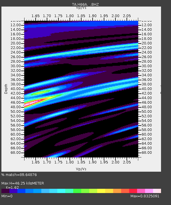
H66A Whiting, ME, USA - Earthquake Result Viewer
| Earthquake location: |
Oaxaca, Mexico |
| Earthquake latitude/longitude: |
17.8/-95.5 |
| Earthquake time(UTC): |
2014/07/29 (210) 10:46:15 GMT |
| Earthquake Depth: |
95 km |
| Earthquake Magnitude: |
6.3 MWP |
| Earthquake Catalog/Contributor: |
NEIC PDE/NEIC COMCAT |
|
| Network: |
TA USArray Transportable Network (new EarthScope stations) |
| Station: |
H66A Whiting, ME, USA |
| Lat/Lon: |
44.79 N/67.31 W |
| Elevation: |
55 m |
|
| Distance: |
35.8 deg |
| Az: |
35.177 deg |
| Baz: |
230.407 deg |
| Ray Param: |
0.0767471 |
| Estimated Moho Depth: |
46.25 km |
| Estimated Crust Vp/Vs: |
1.62 |
| Assumed Crust Vp: |
6.419 km/s |
| Estimated Crust Vs: |
3.962 km/s |
| Estimated Crust Poisson's Ratio: |
0.19 |
|
| Radial Match: |
89.64876 % |
| Radial Bump: |
400 |
| Transverse Match: |
73.93499 % |
| Transverse Bump: |
400 |
| SOD ConfigId: |
769524 |
| Insert Time: |
2014-08-12 11:21:39.203 +0000 |
| GWidth: |
2.5 |
| Max Bumps: |
400 |
| Tol: |
0.001 |
|

Signal To Noise
| Channel | StoN | STA | LTA |
| TA:H66A: :BHZ:20140729T10:52:34.648995Z | 4.2934213 | 9.693205E-7 | 2.2576877E-7 |
| TA:H66A: :BHN:20140729T10:52:34.648995Z | 2.6517708 | 4.276117E-7 | 1.6125514E-7 |
| TA:H66A: :BHE:20140729T10:52:34.648995Z | 3.016785 | 4.2944004E-7 | 1.4235023E-7 |
| Arrivals |
| Ps | 4.8 SECOND |
| PpPs | 17 SECOND |
| PsPs/PpSs | 22 SECOND |


