You are here: Home > Network List > II - Global Seismograph Network (GSN - IRIS/IDA) Stations List
> Station TAU Hobart, Tasmania, Australia > Earthquake Result Viewer
TAU Hobart, Tasmania, Australia - Earthquake Result Viewer
| Earthquake location: |
Solomon Islands |
| Earthquake latitude/longitude: |
-6.5/155.0 |
| Earthquake time(UTC): |
1996/04/29 (120) 14:40:41 GMT |
| Earthquake Depth: |
44 km |
| Earthquake Magnitude: |
6.3 MB, 7.5 MS, 7.2 UNKNOWN, 6.8 ME |
| Earthquake Catalog/Contributor: |
WHDF/NEIC |
|
| Network: |
II Global Seismograph Network (GSN - IRIS/IDA) |
| Station: |
TAU Hobart, Tasmania, Australia |
| Lat/Lon: |
42.91 S/147.32 E |
| Elevation: |
132 m |
|
| Distance: |
36.9 deg |
| Az: |
189.416 deg |
| Baz: |
12.783 deg |
| Ray Param: |
0.07634209 |
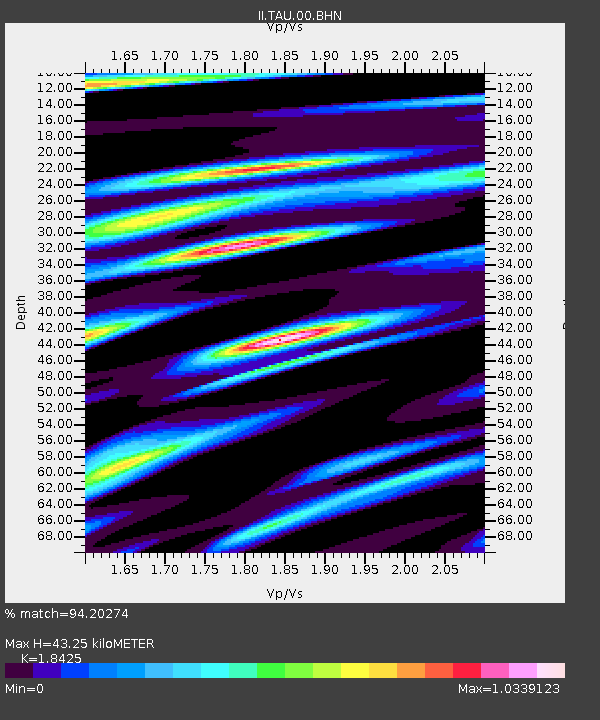
| Estimated Moho Depth: |
43.25 km |
| Estimated Crust Vp/Vs: |
1.84 |
| Assumed Crust Vp: |
6.477 km/s |
| Estimated Crust Vs: |
3.515 km/s |
| Estimated Crust Poisson's Ratio: |
0.29 |
|
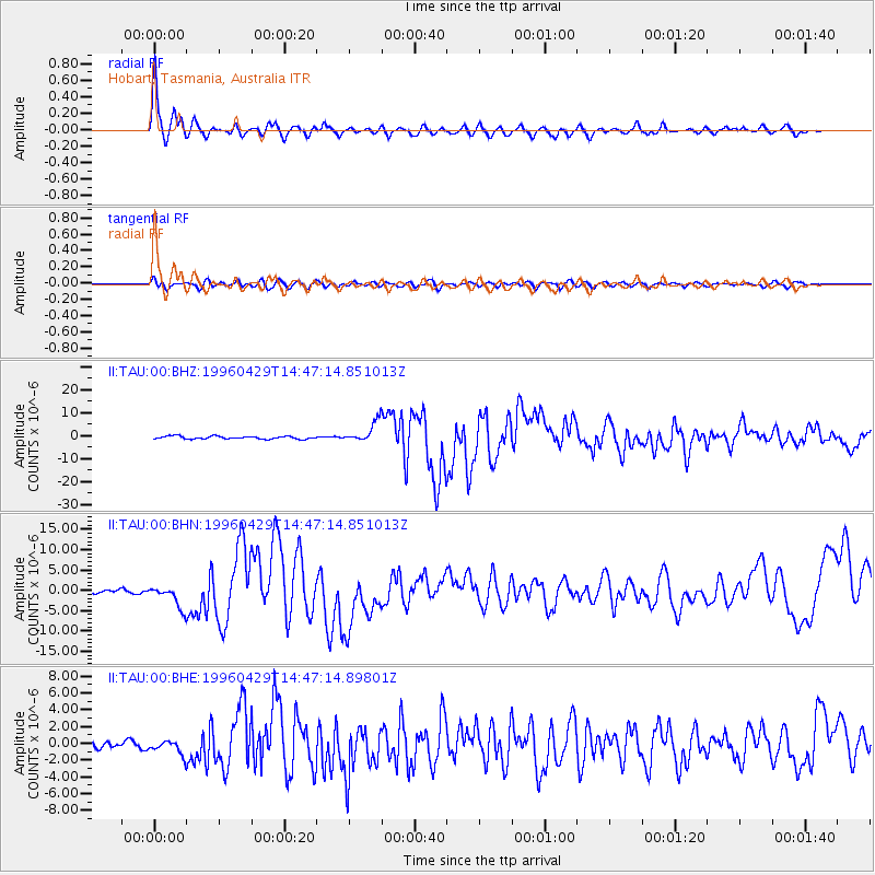
| Radial Match: |
94.20274 % |
| Radial Bump: |
377 |
| Transverse Match: |
74.202194 % |
| Transverse Bump: |
400 |
| SOD ConfigId: |
6273 |
| Insert Time: |
2010-03-02 00:34:09.769 +0000 |
| GWidth: |
2.5 |
| Max Bumps: |
400 |
| Tol: |
0.001 |
|
Signal To Noise
| Channel | StoN | STA | LTA |
| II:TAU:00:BHN:19960429T14:47:14.851013Z | 5.850581 | 2.7116268E-6 | 4.634799E-7 |
| II:TAU:00:BHE:19960429T14:47:14.89801Z | 2.1645975 | 8.598617E-7 | 3.972386E-7 |
| II:TAU:00:BHZ:19960429T14:47:14.851013Z | 7.160421 | 4.434647E-6 | 6.193277E-7 |
| Arrivals |
| Ps | 6.0 SECOND |
| PpPs | 18 SECOND |
| PsPs/PpSs | 24 SECOND |


