You are here: Home > Network List > TA - USArray Transportable Network (new EarthScope stations) Stations List
> Station I03D Drain, OR, USA > Earthquake Result Viewer
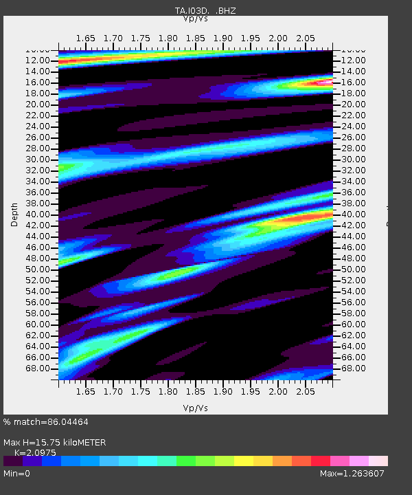
I03D Drain, OR, USA - Earthquake Result Viewer
| Earthquake location: |
Oaxaca, Mexico |
| Earthquake latitude/longitude: |
17.8/-95.5 |
| Earthquake time(UTC): |
2014/07/29 (210) 10:46:15 GMT |
| Earthquake Depth: |
95 km |
| Earthquake Magnitude: |
6.3 MWP |
| Earthquake Catalog/Contributor: |
NEIC PDE/NEIC COMCAT |
|
| Network: |
TA USArray Transportable Network (new EarthScope stations) |
| Station: |
I03D Drain, OR, USA |
| Lat/Lon: |
43.70 N/123.35 W |
| Elevation: |
140 m |
|
| Distance: |
34.9 deg |
| Az: |
323.67 deg |
| Baz: |
128.922 deg |
| Ray Param: |
0.07723513 |
| Estimated Moho Depth: |
15.75 km |
| Estimated Crust Vp/Vs: |
2.10 |
| Assumed Crust Vp: |
6.522 km/s |
| Estimated Crust Vs: |
3.109 km/s |
| Estimated Crust Poisson's Ratio: |
0.35 |
|
| Radial Match: |
86.04464 % |
| Radial Bump: |
400 |
| Transverse Match: |
71.36289 % |
| Transverse Bump: |
400 |
| SOD ConfigId: |
769524 |
| Insert Time: |
2014-08-12 11:21:49.945 +0000 |
| GWidth: |
2.5 |
| Max Bumps: |
400 |
| Tol: |
0.001 |
|

Signal To Noise
| Channel | StoN | STA | LTA |
| TA:I03D: :BHZ:20140729T10:52:26.900002Z | 21.070307 | 2.9108242E-6 | 1.3814817E-7 |
| TA:I03D: :BHN:20140729T10:52:26.900002Z | 9.395675 | 8.814457E-7 | 9.381399E-8 |
| TA:I03D: :BHE:20140729T10:52:26.900002Z | 8.614724 | 1.2263872E-6 | 1.4235943E-7 |
| Arrivals |
| Ps | 2.8 SECOND |
| PpPs | 7.0 SECOND |
| PsPs/PpSs | 9.8 SECOND |


