You are here: Home > Network List > II - Global Seismograph Network (GSN - IRIS/IDA) Stations List
> Station TAU Hobart, Tasmania, Australia > Earthquake Result Viewer
TAU Hobart, Tasmania, Australia - Earthquake Result Viewer
| Earthquake location: |
Samar, Philippines |
| Earthquake latitude/longitude: |
12.6/125.2 |
| Earthquake time(UTC): |
1996/06/11 (163) 18:22:55 GMT |
| Earthquake Depth: |
33 km |
| Earthquake Magnitude: |
6.0 MB, 7.0 MS, 7.2 UNKNOWN, 7.1 MW |
| Earthquake Catalog/Contributor: |
WHDF/NEIC |
|
| Network: |
II Global Seismograph Network (GSN - IRIS/IDA) |
| Station: |
TAU Hobart, Tasmania, Australia |
| Lat/Lon: |
42.91 S/147.32 E |
| Elevation: |
132 m |
|
| Distance: |
58.9 deg |
| Az: |
161.105 deg |
| Baz: |
334.515 deg |
| Ray Param: |
0.06250591 |
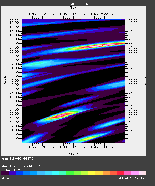
| Estimated Moho Depth: |
22.75 km |
| Estimated Crust Vp/Vs: |
1.99 |
| Assumed Crust Vp: |
6.477 km/s |
| Estimated Crust Vs: |
3.259 km/s |
| Estimated Crust Poisson's Ratio: |
0.33 |
|
| Radial Match: |
93.66879 % |
| Radial Bump: |
332 |
| Transverse Match: |
82.98871 % |
| Transverse Bump: |
400 |
| SOD ConfigId: |
6273 |
| Insert Time: |
2010-03-02 00:34:11.548 +0000 |
| GWidth: |
2.5 |
| Max Bumps: |
400 |
| Tol: |
0.001 |
|
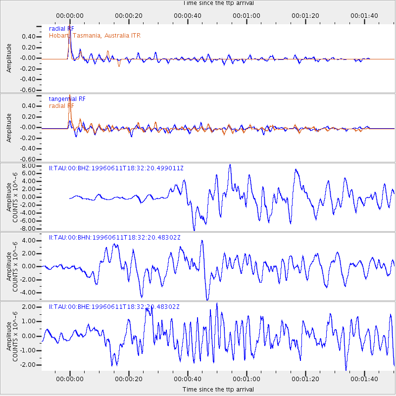
Signal To Noise
| Channel | StoN | STA | LTA |
| II:TAU:00:BHN:19960611T18:32:20.48302Z | 1.0699424 | 2.8713356E-7 | 2.6836358E-7 |
| II:TAU:00:BHE:19960611T18:32:20.48302Z | 0.7104501 | 2.2850075E-7 | 3.2162814E-7 |
| II:TAU:00:BHZ:19960611T18:32:20.499011Z | 2.289689 | 9.296237E-7 | 4.0600435E-7 |
| Arrivals |
| Ps | 3.6 SECOND |
| PpPs | 10 SECOND |
| PsPs/PpSs | 14 SECOND |


