You are here: Home > Network List > TA - USArray Transportable Network (new EarthScope stations) Stations List
> Station J61A Chester, VT, USA > Earthquake Result Viewer
J61A Chester, VT, USA - Earthquake Result Viewer
| Earthquake location: |
Oaxaca, Mexico |
| Earthquake latitude/longitude: |
17.8/-95.5 |
| Earthquake time(UTC): |
2014/07/29 (210) 10:46:15 GMT |
| Earthquake Depth: |
95 km |
| Earthquake Magnitude: |
6.3 MWP |
| Earthquake Catalog/Contributor: |
NEIC PDE/NEIC COMCAT |
|
| Network: |
TA USArray Transportable Network (new EarthScope stations) |
| Station: |
J61A Chester, VT, USA |
| Lat/Lon: |
43.35 N/72.55 W |
| Elevation: |
253 m |
|
| Distance: |
32.0 deg |
| Az: |
32.498 deg |
| Baz: |
224.547 deg |
| Ray Param: |
0.078591384 |
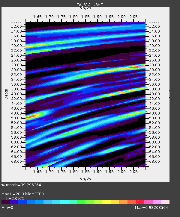
| Estimated Moho Depth: |
28.0 km |
| Estimated Crust Vp/Vs: |
2.10 |
| Assumed Crust Vp: |
6.419 km/s |
| Estimated Crust Vs: |
3.06 km/s |
| Estimated Crust Poisson's Ratio: |
0.35 |
|
| Radial Match: |
89.295364 % |
| Radial Bump: |
309 |
| Transverse Match: |
71.3216 % |
| Transverse Bump: |
400 |
| SOD ConfigId: |
769524 |
| Insert Time: |
2014-08-12 11:23:01.991 +0000 |
| GWidth: |
2.5 |
| Max Bumps: |
400 |
| Tol: |
0.001 |
|
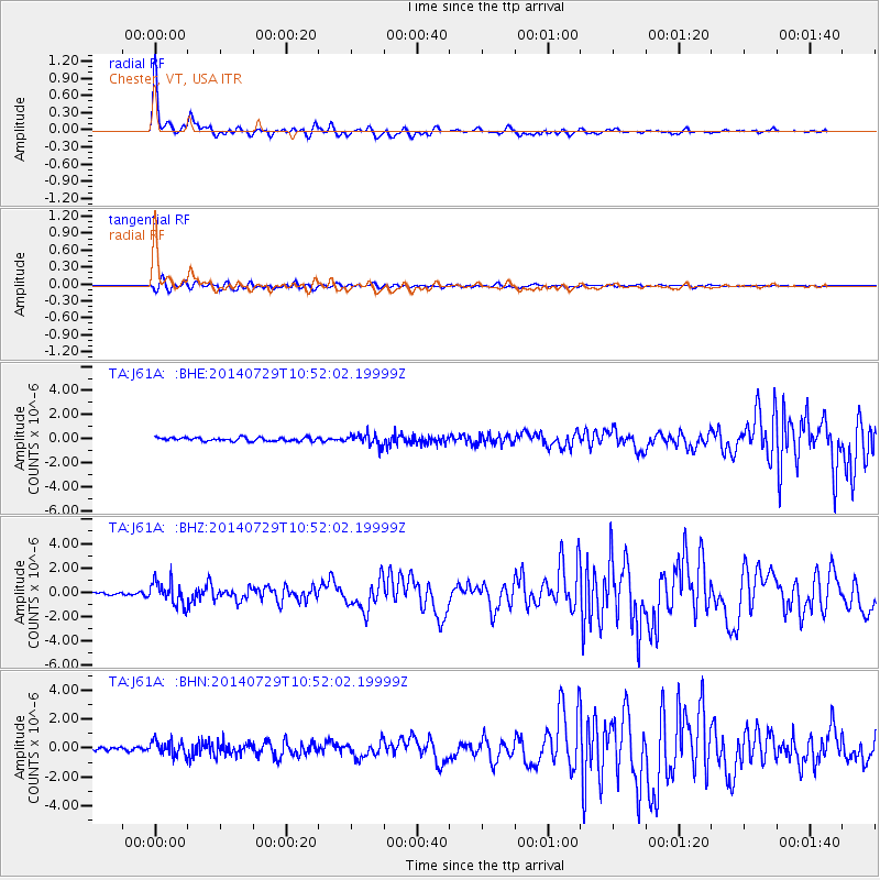
Signal To Noise
| Channel | StoN | STA | LTA |
| TA:J61A: :BHZ:20140729T10:52:02.19999Z | 6.433401 | 9.902677E-7 | 1.53926E-7 |
| TA:J61A: :BHN:20140729T10:52:02.19999Z | 4.047757 | 5.0012767E-7 | 1.2355675E-7 |
| TA:J61A: :BHE:20140729T10:52:02.19999Z | 3.3604023 | 4.951362E-7 | 1.4734432E-7 |
| Arrivals |
| Ps | 5.1 SECOND |
| PpPs | 13 SECOND |
| PsPs/PpSs | 18 SECOND |


