You are here: Home > Network List > II - Global Seismograph Network (GSN - IRIS/IDA) Stations List
> Station TAU Hobart, Tasmania, Australia > Earthquake Result Viewer
TAU Hobart, Tasmania, Australia - Earthquake Result Viewer

| Earthquake location: |
Flores Region, Indonesia |
| Earthquake latitude/longitude: |
-8.9/123.5 |
| Earthquake time(UTC): |
1997/01/17 (017) 11:20:22 GMT |
| Earthquake Depth: |
111 km |
| Earthquake Magnitude: |
6.2 MB, 6.2 UNKNOWN, 6.2 MW |
| Earthquake Catalog/Contributor: |
WHDF/NEIC |
|
| Network: |
II Global Seismograph Network (GSN - IRIS/IDA) |
| Station: |
TAU Hobart, Tasmania, Australia |
| Lat/Lon: |
42.91 S/147.32 E |
| Elevation: |
132 m |
|
| Distance: |
39.8 deg |
| Az: |
152.415 deg |
| Baz: |
321.48 deg |
| Ray Param: |
0.07441457 |
| Estimated Moho Depth: |
41.0 km |
| Estimated Crust Vp/Vs: |
1.61 |
| Assumed Crust Vp: |
6.477 km/s |
| Estimated Crust Vs: |
4.029 km/s |
| Estimated Crust Poisson's Ratio: |
0.18 |
|
| Radial Match: |
84.82238 % |
| Radial Bump: |
379 |
| Transverse Match: |
59.62779 % |
| Transverse Bump: |
400 |
| SOD ConfigId: |
6273 |
| Insert Time: |
2010-03-02 00:34:17.956 +0000 |
| GWidth: |
2.5 |
| Max Bumps: |
400 |
| Tol: |
0.001 |
|
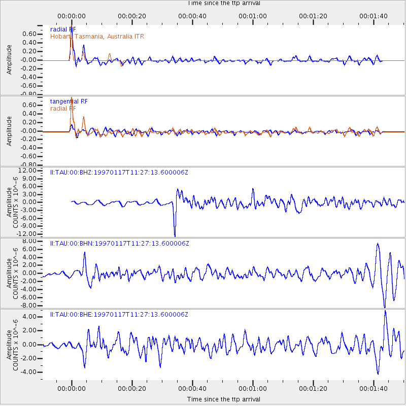
Signal To Noise
| Channel | StoN | STA | LTA |
| II:TAU:00:BHN:19970117T11:27:13.600006Z | 3.9140756 | 1.7281747E-6 | 4.415282E-7 |
| II:TAU:00:BHE:19970117T11:27:13.600006Z | 3.6605675 | 1.0863349E-6 | 2.967668E-7 |
| II:TAU:00:BHZ:19970117T11:27:13.600006Z | 6.6851163 | 3.819351E-6 | 5.713216E-7 |
| Arrivals |
| Ps | 4.2 SECOND |
| PpPs | 15 SECOND |
| PsPs/PpSs | 19 SECOND |


