You are here: Home > Network List > II - Global Seismograph Network (GSN - IRIS/IDA) Stations List
> Station TAU Hobart, Tasmania, Australia > Earthquake Result Viewer
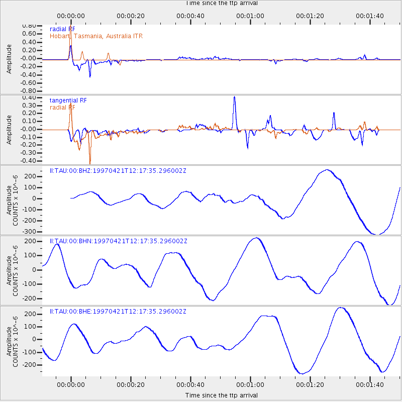
TAU Hobart, Tasmania, Australia - Earthquake Result Viewer

| Earthquake location: |
Vanuatu Islands |
| Earthquake latitude/longitude: |
-13.5/166.5 |
| Earthquake time(UTC): |
1997/04/21 (111) 12:11:27 GMT |
| Earthquake Depth: |
33 km |
| Earthquake Magnitude: |
6.2 MB |
| Earthquake Catalog/Contributor: |
WHDF/NEIC |
|
| Network: |
II Global Seismograph Network (GSN - IRIS/IDA) |
| Station: |
TAU Hobart, Tasmania, Australia |
| Lat/Lon: |
42.91 S/147.32 E |
| Elevation: |
132 m |
|
| Distance: |
33.7 deg |
| Az: |
205.862 deg |
| Baz: |
35.276 deg |
| Ray Param: |
0.07804494 |
| Estimated Moho Depth: |
14.25 km |
| Estimated Crust Vp/Vs: |
1.60 |
| Assumed Crust Vp: |
6.477 km/s |
| Estimated Crust Vs: |
4.048 km/s |
| Estimated Crust Poisson's Ratio: |
0.18 |
|
| Radial Match: |
94.510735 % |
| Radial Bump: |
305 |
| Transverse Match: |
69.06294 % |
| Transverse Bump: |
400 |
| SOD ConfigId: |
6273 |
| Insert Time: |
2010-03-02 00:34:20.359 +0000 |
| GWidth: |
2.5 |
| Max Bumps: |
400 |
| Tol: |
0.001 |
|
Signal To Noise
| Channel | StoN | STA | LTA |
| II:TAU:00:BHN:19970421T12:17:35.296002Z | 0.87325215 | 9.277858E-5 | 1.06244894E-4 |
| II:TAU:00:BHE:19970421T12:17:35.296002Z | 0.8087785 | 9.80161E-5 | 1.2119028E-4 |
| II:TAU:00:BHZ:19970421T12:17:35.296002Z | 2.0492563 | 7.541969E-5 | 3.680344E-5 |
| Arrivals |
| Ps | 1.4 SECOND |
| PpPs | 5.2 SECOND |
| PsPs/PpSs | 6.7 SECOND |


