You are here: Home > Network List > TA - USArray Transportable Network (new EarthScope stations) Stations List
> Station M63A Gales Ferry, CT, USA > Earthquake Result Viewer
M63A Gales Ferry, CT, USA - Earthquake Result Viewer
| Earthquake location: |
Oaxaca, Mexico |
| Earthquake latitude/longitude: |
17.8/-95.5 |
| Earthquake time(UTC): |
2014/07/29 (210) 10:46:15 GMT |
| Earthquake Depth: |
95 km |
| Earthquake Magnitude: |
6.3 MWP |
| Earthquake Catalog/Contributor: |
NEIC PDE/NEIC COMCAT |
|
| Network: |
TA USArray Transportable Network (new EarthScope stations) |
| Station: |
M63A Gales Ferry, CT, USA |
| Lat/Lon: |
41.40 N/72.05 W |
| Elevation: |
44 m |
|
| Distance: |
30.9 deg |
| Az: |
35.676 deg |
| Baz: |
227.599 deg |
| Ray Param: |
0.07904682 |
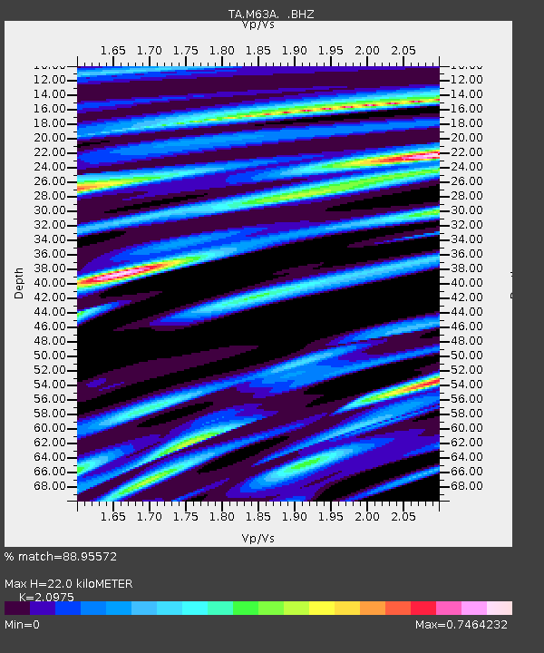
| Estimated Moho Depth: |
22.0 km |
| Estimated Crust Vp/Vs: |
2.10 |
| Assumed Crust Vp: |
6.472 km/s |
| Estimated Crust Vs: |
3.086 km/s |
| Estimated Crust Poisson's Ratio: |
0.35 |
|
| Radial Match: |
88.95572 % |
| Radial Bump: |
365 |
| Transverse Match: |
69.45762 % |
| Transverse Bump: |
400 |
| SOD ConfigId: |
769524 |
| Insert Time: |
2014-08-12 11:24:33.007 +0000 |
| GWidth: |
2.5 |
| Max Bumps: |
400 |
| Tol: |
0.001 |
|

Signal To Noise
| Channel | StoN | STA | LTA |
| TA:M63A: :BHZ:20140729T10:51:52.799996Z | 2.4322083 | 1.1262142E-6 | 4.6304183E-7 |
| TA:M63A: :BHN:20140729T10:51:52.799996Z | 1.9468819 | 5.2752495E-7 | 2.7095888E-7 |
| TA:M63A: :BHE:20140729T10:51:52.799996Z | 2.4899156 | 6.2282305E-7 | 2.5013824E-7 |
| Arrivals |
| Ps | 4.0 SECOND |
| PpPs | 9.8 SECOND |
| PsPs/PpSs | 14 SECOND |


