You are here: Home > Network List > II - Global Seismograph Network (GSN - IRIS/IDA) Stations List
> Station TAU Hobart, Tasmania, Australia > Earthquake Result Viewer
TAU Hobart, Tasmania, Australia - Earthquake Result Viewer
| Earthquake location: |
Fiji Islands Region |
| Earthquake latitude/longitude: |
-17.6/-179.1 |
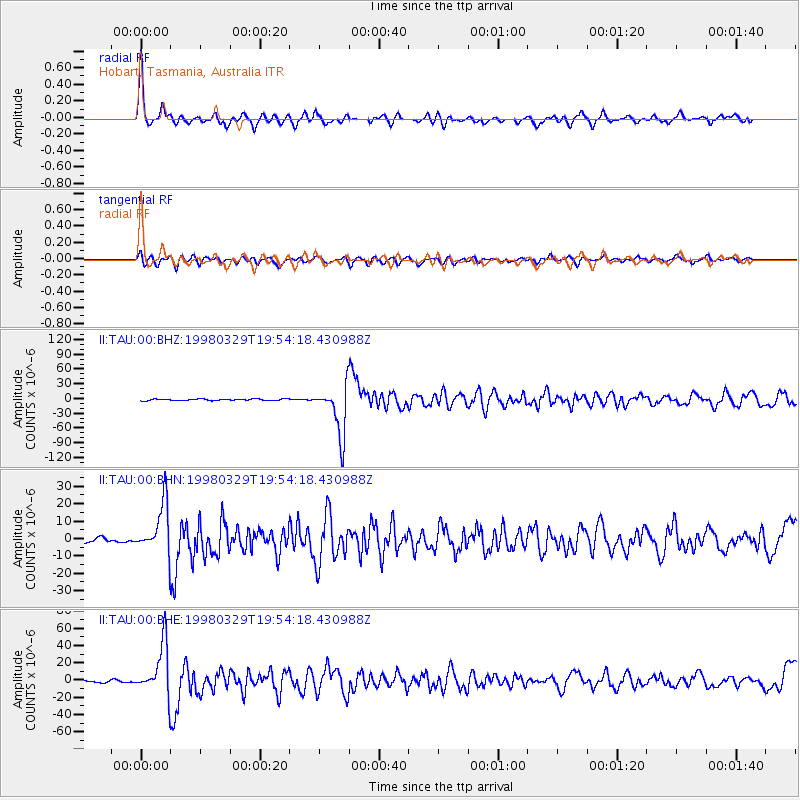
| Earthquake time(UTC): |
1998/03/29 (088) 19:48:16 GMT |
| Earthquake Depth: |
537 km |
| Earthquake Magnitude: |
6.5 MB, 7.2 UNKNOWN, 7.1 MW |
| Earthquake Catalog/Contributor: |
WHDF/NEIC |
|
| Network: |
II Global Seismograph Network (GSN - IRIS/IDA) |
| Station: |
TAU Hobart, Tasmania, Australia |
| Lat/Lon: |
42.91 S/147.32 E |
| Elevation: |
132 m |
|
| Distance: |
38.1 deg |
| Az: |
221.232 deg |
| Baz: |
58.856 deg |
| Ray Param: |
0.07312095 |
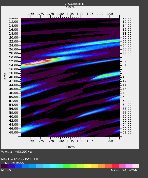
| Estimated Moho Depth: |
32.25 km |
| Estimated Crust Vp/Vs: |
1.69 |
| Assumed Crust Vp: |
6.477 km/s |
| Estimated Crust Vs: |
3.844 km/s |
| Estimated Crust Poisson's Ratio: |
0.23 |
|
| Radial Match: |
83.20146 % |
| Radial Bump: |
400 |
| Transverse Match: |
64.08789 % |
| Transverse Bump: |
400 |
| SOD ConfigId: |
6273 |
| Insert Time: |
2010-03-02 00:34:33.217 +0000 |
| GWidth: |
2.5 |
| Max Bumps: |
400 |
| Tol: |
0.001 |
|
Signal To Noise
| Channel | StoN | STA | LTA |
| II:TAU:00:BHN:19980329T19:54:18.430988Z | 11.401444 | 1.4622655E-5 | 1.2825265E-6 |
| II:TAU:00:BHE:19980329T19:54:18.430988Z | 21.60624 | 2.9998579E-5 | 1.388422E-6 |
| II:TAU:00:BHZ:19980329T19:54:18.430988Z | 32.148617 | 5.070528E-5 | 1.5772149E-6 |
| Arrivals |
| Ps | 3.7 SECOND |
| PpPs | 12 SECOND |
| PsPs/PpSs | 16 SECOND |


