You are here: Home > Network List > UU - University of Utah Regional Network Stations List
> Station ASI2 Darling Creek, Challis, ID, USA > Earthquake Result Viewer
ASI2 Darling Creek, Challis, ID, USA - Earthquake Result Viewer
| Earthquake location: |
Oaxaca, Mexico |
| Earthquake latitude/longitude: |
17.8/-95.5 |
| Earthquake time(UTC): |
2014/07/29 (210) 10:46:15 GMT |
| Earthquake Depth: |
95 km |
| Earthquake Magnitude: |
6.3 MWP |
| Earthquake Catalog/Contributor: |
NEIC PDE/NEIC COMCAT |
|
| Network: |
UU University of Utah Regional Network |
| Station: |
ASI2 Darling Creek, Challis, ID, USA |
| Lat/Lon: |
44.57 N/114.26 W |
| Elevation: |
1600 m |
|
| Distance: |
30.9 deg |
| Az: |
333.486 deg |
| Baz: |
143.491 deg |
| Ray Param: |
0.07903854 |
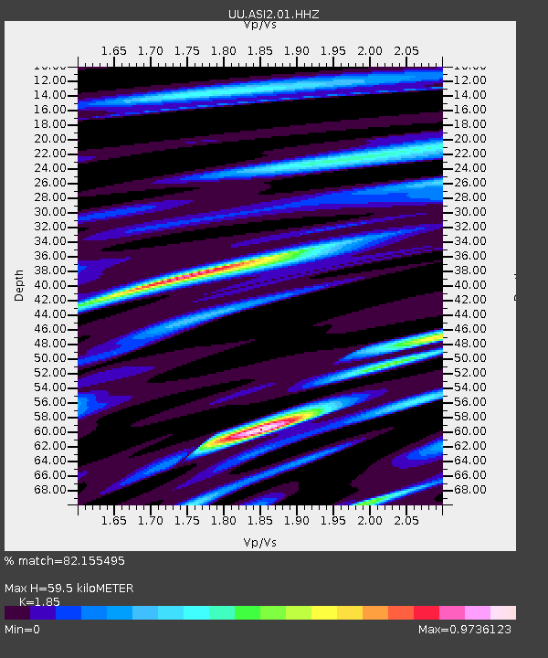
| Estimated Moho Depth: |
59.5 km |
| Estimated Crust Vp/Vs: |
1.85 |
| Assumed Crust Vp: |
6.577 km/s |
| Estimated Crust Vs: |
3.555 km/s |
| Estimated Crust Poisson's Ratio: |
0.29 |
|
| Radial Match: |
82.155495 % |
| Radial Bump: |
400 |
| Transverse Match: |
54.343918 % |
| Transverse Bump: |
381 |
| SOD ConfigId: |
769524 |
| Insert Time: |
2014-08-12 11:27:15.382 +0000 |
| GWidth: |
2.5 |
| Max Bumps: |
400 |
| Tol: |
0.001 |
|

Signal To Noise
| Channel | StoN | STA | LTA |
| UU:ASI2:01:HHZ:20140729T10:51:52.957986Z | 16.080242 | 6.8702626E-8 | 4.2724873E-9 |
| UU:ASI2:01:HHN:20140729T10:51:52.957986Z | 4.3020477 | 2.9398183E-8 | 6.833533E-9 |
| UU:ASI2:01:HHE:20140729T10:51:52.957986Z | 2.707503 | 2.1313253E-8 | 7.871922E-9 |
| Arrivals |
| Ps | 8.3 SECOND |
| PpPs | 24 SECOND |
| PsPs/PpSs | 32 SECOND |


