You are here: Home > Network List > UW - Pacific Northwest Regional Seismic Network Stations List
> Station LTY Liberty (broad-band) > Earthquake Result Viewer
LTY Liberty (broad-band) - Earthquake Result Viewer
| Earthquake location: |
Oaxaca, Mexico |
| Earthquake latitude/longitude: |
17.8/-95.5 |
| Earthquake time(UTC): |
2014/07/29 (210) 10:46:15 GMT |
| Earthquake Depth: |
95 km |
| Earthquake Magnitude: |
6.3 MWP |
| Earthquake Catalog/Contributor: |
NEIC PDE/NEIC COMCAT |
|
| Network: |
UW Pacific Northwest Regional Seismic Network |
| Station: |
LTY Liberty (broad-band) |
| Lat/Lon: |
47.26 N/120.66 W |
| Elevation: |
970 m |
|
| Distance: |
35.9 deg |
| Az: |
330.406 deg |
| Baz: |
136.326 deg |
| Ray Param: |
0.07668403 |
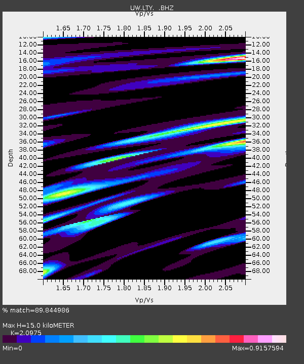
| Estimated Moho Depth: |
15.0 km |
| Estimated Crust Vp/Vs: |
2.10 |
| Assumed Crust Vp: |
6.597 km/s |
| Estimated Crust Vs: |
3.145 km/s |
| Estimated Crust Poisson's Ratio: |
0.35 |
|
| Radial Match: |
89.844986 % |
| Radial Bump: |
400 |
| Transverse Match: |
89.76161 % |
| Transverse Bump: |
400 |
| SOD ConfigId: |
769524 |
| Insert Time: |
2014-08-12 11:28:32.930 +0000 |
| GWidth: |
2.5 |
| Max Bumps: |
400 |
| Tol: |
0.001 |
|

Signal To Noise
| Channel | StoN | STA | LTA |
| UW:LTY: :BHZ:20140729T10:52:35.630013Z | 106.15585 | 3.996659E-6 | 3.7648974E-8 |
| UW:LTY: :BHN:20140729T10:52:35.630013Z | 31.57592 | 1.576083E-6 | 4.991408E-8 |
| UW:LTY: :BHE:20140729T10:52:35.630013Z | 19.47153 | 7.2843113E-7 | 3.7410057E-8 |
| Arrivals |
| Ps | 2.7 SECOND |
| PpPs | 6.6 SECOND |
| PsPs/PpSs | 9.3 SECOND |


