You are here: Home > Network List > II - Global Seismograph Network (GSN - IRIS/IDA) Stations List
> Station TAU Hobart, Tasmania, Australia > Earthquake Result Viewer
TAU Hobart, Tasmania, Australia - Earthquake Result Viewer
| Earthquake location: |
Java, Indonesia |
| Earthquake latitude/longitude: |
-5.9/107.7 |
| Earthquake time(UTC): |
2007/08/08 (220) 17:04:57 GMT |
| Earthquake Depth: |
291 km |
| Earthquake Magnitude: |
6.1 MB |
| Earthquake Catalog/Contributor: |
WHDF/NEIC |
|
| Network: |
II Global Seismograph Network (GSN - IRIS/IDA) |
| Station: |
TAU Hobart, Tasmania, Australia |
| Lat/Lon: |
42.91 S/147.32 E |
| Elevation: |
132 m |
|
| Distance: |
50.8 deg |
| Az: |
142.768 deg |
| Baz: |
304.998 deg |
| Ray Param: |
0.06672468 |
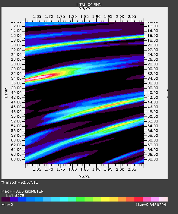
| Estimated Moho Depth: |
33.5 km |
| Estimated Crust Vp/Vs: |
1.65 |
| Assumed Crust Vp: |
6.477 km/s |
| Estimated Crust Vs: |
3.931 km/s |
| Estimated Crust Poisson's Ratio: |
0.21 |
|
| Radial Match: |
92.07511 % |
| Radial Bump: |
400 |
| Transverse Match: |
65.63342 % |
| Transverse Bump: |
400 |
| SOD ConfigId: |
2564 |
| Insert Time: |
2010-03-02 00:34:51.965 +0000 |
| GWidth: |
2.5 |
| Max Bumps: |
400 |
| Tol: |
0.001 |
|

Signal To Noise
| Channel | StoN | STA | LTA |
| II:TAU:00:BHN:20070808T17:12:58.220005Z | 1.3526033 | 1.5753884E-6 | 1.1647084E-6 |
| II:TAU:00:BHE:20070808T17:12:58.220005Z | 2.0895493 | 3.2921682E-6 | 1.57554E-6 |
| II:TAU:00:BHZ:20070808T17:12:58.220005Z | 1.397864 | 4.1997982E-6 | 3.0044396E-6 |
| Arrivals |
| Ps | 3.6 SECOND |
| PpPs | 13 SECOND |
| PsPs/PpSs | 16 SECOND |


