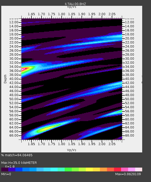
TAU Hobart, Tasmania, Australia - Earthquake Result Viewer

Earthquake location: Minahassa Peninsula, Sulawesi
Earthquake latitude/longitude: 1.3/122.1
Earthquake time(UTC): 2008/11/16 (321) 17:02:32 GMT
Earthquake Depth: 30 km
Earthquake Magnitude: 6.5 MB, 7.0 MS, 7.3 MW, 7.3 MW
Earthquake Catalog/Contributor: WHDF/NEIC
Network: II Global Seismograph Network (GSN - IRIS/IDA)
Station: TAU Hobart, Tasmania, Australia
Lat/Lon: 42.91 S/147.32 E
Elevation: 132 m
Distance: 49.5 deg
Az: 155.678 deg
Baz: 325.913 deg
Ray Param: 0.0686102
Estimated Moho Depth: 35.0 km
Estimated Crust Vp/Vs: 1.60
Assumed Crust Vp: 6.477 km/s
Estimated Crust Vs: 4.048 km/s
Estimated Crust Poisson's Ratio: 0.18
Radial Match: 94.06465 %
Radial Bump: 266
Transverse Match: 81.30954 %
Transverse Bump: 400
SOD ConfigId: 2658
Insert Time: 2010-03-02 00:34:59.306 +0000
GWidth: 2.5
Max Bumps: 400
Tol: 0.001

Signal To Noise

ChannelStoNSTALTA
II:TAU:00:BHZ:20081116T17:10:49.670001Z9.5311489.103104E-69.5509E-7
II:TAU:00:BHN:20081116T17:10:49.670001Z5.0643644.4885282E-68.8629656E-7
II:TAU:00:BHE:20081116T17:10:49.670001Z3.44007472.6466716E-67.693646E-7
Arrivals
Ps3.5 SECOND
PpPs13 SECOND
PsPs/PpSs17 SECOND