You are here: Home > Network List > TA - USArray Transportable Network (new EarthScope stations) Stations List
> Station X43A Marvell, AR, USA > Earthquake Result Viewer
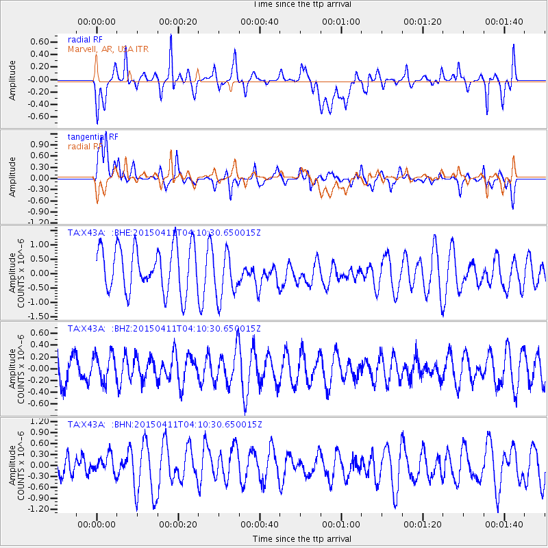
X43A Marvell, AR, USA - Earthquake Result Viewer
*The percent match for this event was below the threshold and hence no stack was calculated.
| Earthquake location: |
Northwest Of Kuril Islands |
| Earthquake latitude/longitude: |
52.0/153.2 |
| Earthquake time(UTC): |
2015/04/11 (101) 03:59:53 GMT |
| Earthquake Depth: |
433 km |
| Earthquake Magnitude: |
4.7 mb, 4.7 mb |
| Earthquake Catalog/Contributor: |
ISC/ISC |
|
| Network: |
TA USArray Transportable Network (new EarthScope stations) |
| Station: |
X43A Marvell, AR, USA |
| Lat/Lon: |
34.52 N/90.88 W |
| Elevation: |
53 m |
|
| Distance: |
77.3 deg |
| Az: |
49.59 deg |
| Baz: |
325.281 deg |
| Ray Param: |
$rayparam |
*The percent match for this event was below the threshold and hence was not used in the summary stack. |
|
| Radial Match: |
39.15946 % |
| Radial Bump: |
400 |
| Transverse Match: |
63.14503 % |
| Transverse Bump: |
400 |
| SOD ConfigId: |
7422571 |
| Insert Time: |
2019-04-18 03:45:00.025 +0000 |
| GWidth: |
2.5 |
| Max Bumps: |
400 |
| Tol: |
0.001 |
|
Signal To Noise
| Channel | StoN | STA | LTA |
| TA:X43A: :BHZ:20150411T04:10:30.650015Z | 1.0707939 | 2.3919588E-7 | 2.2338182E-7 |
| TA:X43A: :BHN:20150411T04:10:30.650015Z | 0.63932717 | 3.5393447E-7 | 5.536046E-7 |
| TA:X43A: :BHE:20150411T04:10:30.650015Z | 1.0948306 | 8.564469E-7 | 7.8226424E-7 |
| Arrivals |
| Ps | |
| PpPs | |
| PsPs/PpSs | |


