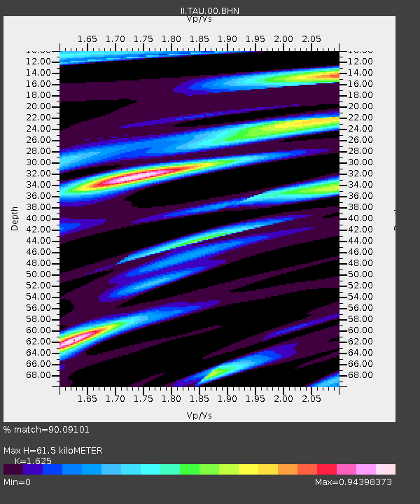
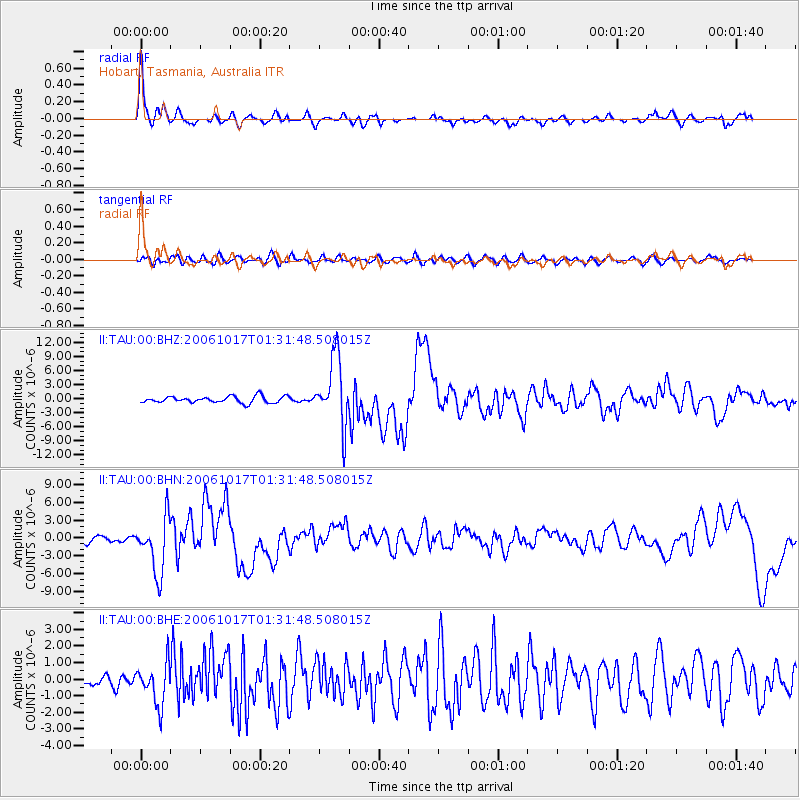
TAU Hobart, Tasmania, Australia - Earthquake Result Viewer

Earthquake location: New Britain Region, P.N.G.
Earthquake latitude/longitude: -5.9/151.0
Earthquake time(UTC): 2006/10/17 (290) 01:25:12 GMT
Earthquake Depth: 32 km
Earthquake Magnitude: 6.4 MB, 6.9 MS, 6.7 MW, 6.6 MW
Earthquake Catalog/Contributor: WHDF/NEIC
Network: II Global Seismograph Network (GSN - IRIS/IDA)
Station: TAU Hobart, Tasmania, Australia
Lat/Lon: 42.91 S/147.32 E
Elevation: 132 m
Distance: 37.0 deg
Az: 184.47 deg
Baz: 6.057 deg
Ray Param: 0.076306276
Estimated Moho Depth: 61.5 km
Estimated Crust Vp/Vs: 1.62
Assumed Crust Vp: 6.477 km/s
Estimated Crust Vs: 3.986 km/s
Estimated Crust Poisson's Ratio: 0.20
Radial Match: 90.09101 %
Radial Bump: 373
Transverse Match: 69.06548 %
Transverse Bump: 400
SOD ConfigId: 2665
Insert Time: 2010-03-02 00:35:11.483 +0000
GWidth: 2.5
Max Bumps: 400
Tol: 0.001

Signal To Noise

ChannelStoNSTALTA
II:TAU:00:BHN:20061017T01:31:48.508015Z8.5370814.686198E-65.4892274E-7
II:TAU:00:BHE:20061017T01:31:48.508015Z2.44883941.2444841E-65.081934E-7
II:TAU:00:BHZ:20061017T01:31:48.508015Z10.35043057.1526297E-66.910466E-7
Arrivals
Ps6.4 SECOND
PpPs23 SECOND
PsPs/PpSs29 SECOND