You are here: Home > Network List > IU - Global Seismograph Network (GSN - IRIS/USGS) Stations List
> Station MAJO Matsushiro, Japan > Earthquake Result Viewer
MAJO Matsushiro, Japan - Earthquake Result Viewer
| Earthquake location: |
Bismarck Sea |
| Earthquake latitude/longitude: |
-3.5/146.7 |
| Earthquake time(UTC): |
2014/07/29 (210) 13:27:40 GMT |
| Earthquake Depth: |
6.9 km |
| Earthquake Magnitude: |
5.8 MB |
| Earthquake Catalog/Contributor: |
NEIC PDE/NEIC COMCAT |
|
| Network: |
IU Global Seismograph Network (GSN - IRIS/USGS) |
| Station: |
MAJO Matsushiro, Japan |
| Lat/Lon: |
36.55 N/138.20 E |
| Elevation: |
405 m |
|
| Distance: |
40.6 deg |
| Az: |
349.491 deg |
| Baz: |
166.933 deg |
| Ray Param: |
0.074322864 |
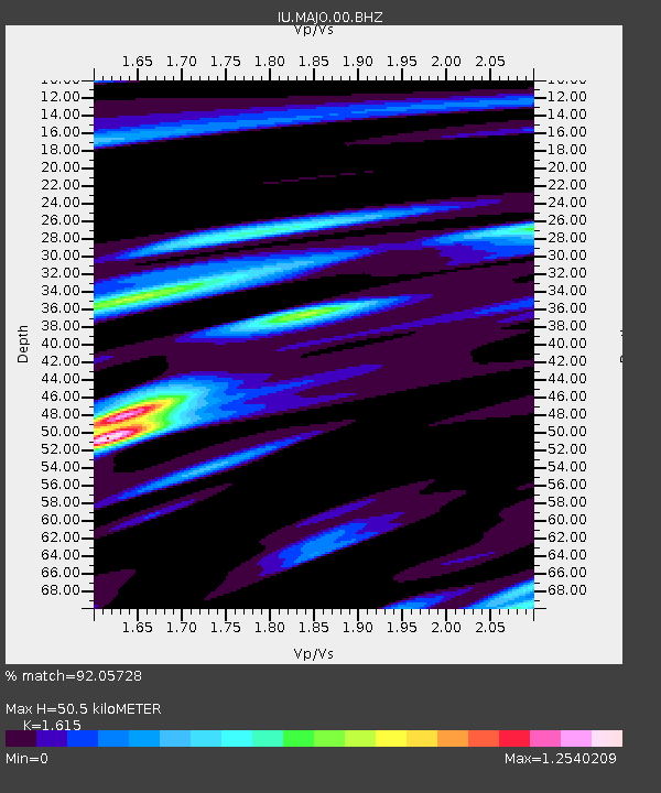
| Estimated Moho Depth: |
50.5 km |
| Estimated Crust Vp/Vs: |
1.62 |
| Assumed Crust Vp: |
6.461 km/s |
| Estimated Crust Vs: |
4.001 km/s |
| Estimated Crust Poisson's Ratio: |
0.19 |
|
| Radial Match: |
92.05728 % |
| Radial Bump: |
373 |
| Transverse Match: |
88.88894 % |
| Transverse Bump: |
400 |
| SOD ConfigId: |
769524 |
| Insert Time: |
2014-08-12 13:45:14.947 +0000 |
| GWidth: |
2.5 |
| Max Bumps: |
400 |
| Tol: |
0.001 |
|
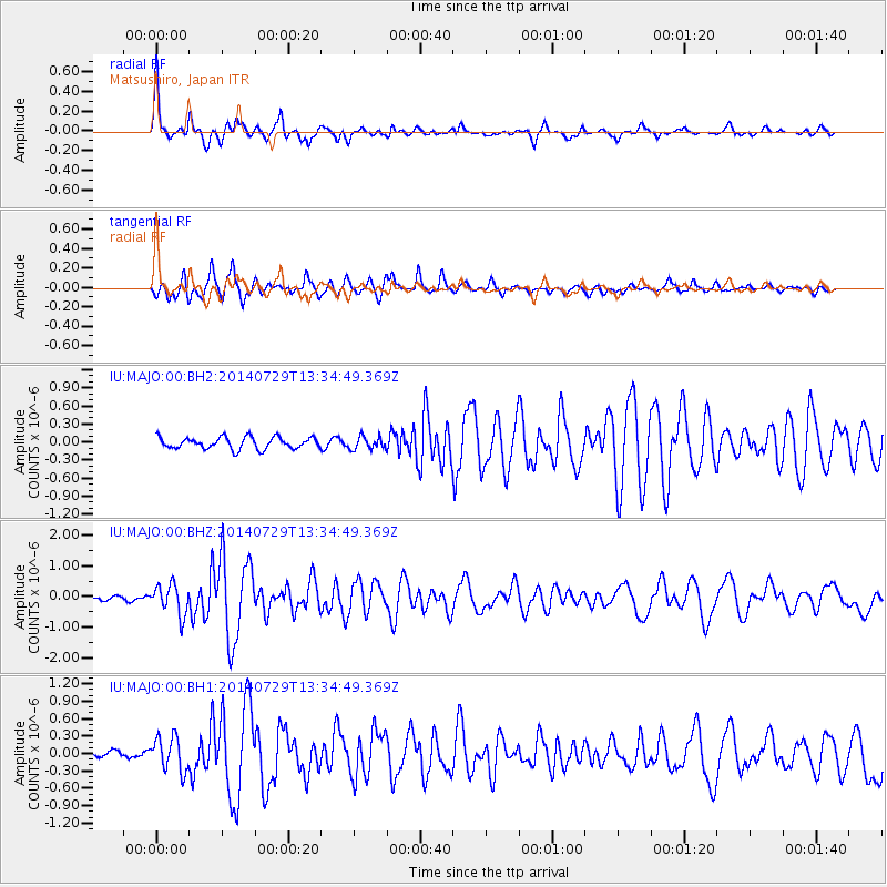
Signal To Noise
| Channel | StoN | STA | LTA |
| IU:MAJO:00:BHZ:20140729T13:34:49.369Z | 9.813662 | 4.9262707E-7 | 5.019809E-8 |
| IU:MAJO:00:BH1:20140729T13:34:49.369Z | 4.080632 | 2.9549003E-7 | 7.24128E-8 |
| IU:MAJO:00:BH2:20140729T13:34:49.369Z | 1.0767528 | 1.0406356E-7 | 9.6645735E-8 |
| Arrivals |
| Ps | 5.2 SECOND |
| PpPs | 19 SECOND |
| PsPs/PpSs | 24 SECOND |


