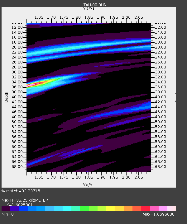
TAU Hobart, Tasmania, Australia - Earthquake Result Viewer

Earthquake location: Northern Sumatra, Indonesia
Earthquake latitude/longitude: 0.1/97.1
Earthquake time(UTC): 2006/05/16 (136) 15:28:25 GMT
Earthquake Depth: 12 km
Earthquake Magnitude: 6.6 MB, 6.8 MS, 6.8 MW, 6.8 MW
Earthquake Catalog/Contributor: WHDF/NEIC
Network: II Global Seismograph Network (GSN - IRIS/IDA)
Station: TAU Hobart, Tasmania, Australia
Lat/Lon: 42.91 S/147.32 E
Elevation: 132 m
Distance: 62.1 deg
Az: 140.24 deg
Baz: 299.481 deg
Ray Param: 0.0604701
Estimated Moho Depth: 35.25 km
Estimated Crust Vp/Vs: 1.60
Assumed Crust Vp: 6.477 km/s
Estimated Crust Vs: 4.042 km/s
Estimated Crust Poisson's Ratio: 0.18
Radial Match: 93.23715 %
Radial Bump: 316
Transverse Match: 87.489456 %
Transverse Bump: 400
SOD ConfigId: 2669
Insert Time: 2010-03-02 00:35:17.390 +0000
GWidth: 2.5
Max Bumps: 400
Tol: 0.001

Signal To Noise

ChannelStoNSTALTA
II:TAU:00:BHN:20060516T15:38:15.154009Z4.7796272.011791E-64.2090963E-7
II:TAU:00:BHE:20060516T15:38:15.154009Z6.6272122.6098626E-63.9381E-7
II:TAU:00:BHZ:20060516T15:38:15.154009Z20.1504767.6966835E-63.8196038E-7
Arrivals
Ps3.4 SECOND
PpPs13 SECOND
PsPs/PpSs17 SECOND