You are here: Home > Network List > KZ - Kazakhstan Network Stations List
> Station MKAR Makanchi array,MK31, Kazakhstan > Earthquake Result Viewer
MKAR Makanchi array,MK31, Kazakhstan - Earthquake Result Viewer
| Earthquake location: |
Bismarck Sea |
| Earthquake latitude/longitude: |
-3.5/146.7 |
| Earthquake time(UTC): |
2014/07/29 (210) 13:27:40 GMT |
| Earthquake Depth: |
6.9 km |
| Earthquake Magnitude: |
5.8 MB |
| Earthquake Catalog/Contributor: |
NEIC PDE/NEIC COMCAT |
|
| Network: |
KZ Kazakhstan Network |
| Station: |
MKAR Makanchi array,MK31, Kazakhstan |
| Lat/Lon: |
46.79 N/82.29 E |
| Elevation: |
615 m |
|
| Distance: |
75.4 deg |
| Az: |
320.182 deg |
| Baz: |
111.514 deg |
| Ray Param: |
0.051730037 |
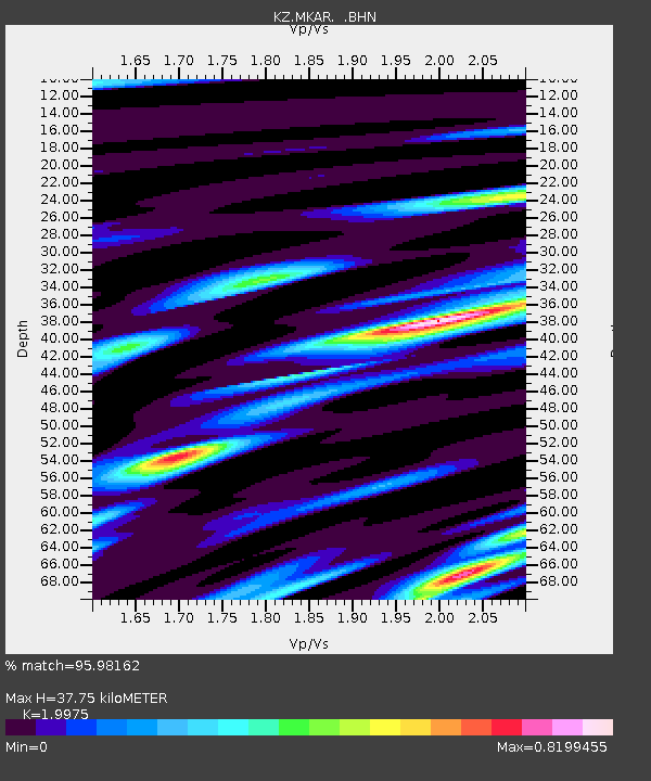
| Estimated Moho Depth: |
37.75 km |
| Estimated Crust Vp/Vs: |
2.00 |
| Assumed Crust Vp: |
6.688 km/s |
| Estimated Crust Vs: |
3.348 km/s |
| Estimated Crust Poisson's Ratio: |
0.33 |
|
| Radial Match: |
95.98162 % |
| Radial Bump: |
400 |
| Transverse Match: |
93.797516 % |
| Transverse Bump: |
400 |
| SOD ConfigId: |
769524 |
| Insert Time: |
2014-08-12 13:47:15.603 +0000 |
| GWidth: |
2.5 |
| Max Bumps: |
400 |
| Tol: |
0.001 |
|

Signal To Noise
| Channel | StoN | STA | LTA |
| KZ:MKAR: :BHZ:20140729T13:38:52.750012Z | 7.915494 | 4.8315457E-7 | 6.1039096E-8 |
| KZ:MKAR: :BHN:20140729T13:38:52.750012Z | 2.8921533 | 7.9387895E-8 | 2.7449408E-8 |
| KZ:MKAR: :BHE:20140729T13:38:52.750012Z | 5.258904 | 1.3941312E-7 | 2.650992E-8 |
| Arrivals |
| Ps | 5.8 SECOND |
| PpPs | 16 SECOND |
| PsPs/PpSs | 22 SECOND |


