You are here: Home > Network List > II - Global Seismograph Network (GSN - IRIS/IDA) Stations List
> Station TAU Hobart, Tasmania, Australia > Earthquake Result Viewer
TAU Hobart, Tasmania, Australia - Earthquake Result Viewer
| Earthquake location: |
Tonga Islands |
| Earthquake latitude/longitude: |
-20.2/-174.1 |
| Earthquake time(UTC): |
2006/05/03 (123) 15:26:40 GMT |
| Earthquake Depth: |
55 km |
| Earthquake Magnitude: |
7.2 MB, 7.8 MS, 7.9 MW, 7.9 MW |
| Earthquake Catalog/Contributor: |
WHDF/NEIC |
|
| Network: |
II Global Seismograph Network (GSN - IRIS/IDA) |
| Station: |
TAU Hobart, Tasmania, Australia |
| Lat/Lon: |
42.91 S/147.32 E |
| Elevation: |
132 m |
|
| Distance: |
39.4 deg |
| Az: |
226.135 deg |
| Baz: |
67.187 deg |
| Ray Param: |
0.07483999 |
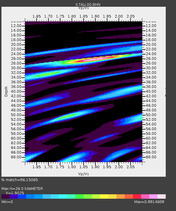
| Estimated Moho Depth: |
26.0 km |
| Estimated Crust Vp/Vs: |
1.90 |
| Assumed Crust Vp: |
6.477 km/s |
| Estimated Crust Vs: |
3.404 km/s |
| Estimated Crust Poisson's Ratio: |
0.31 |
|
| Radial Match: |
96.15065 % |
| Radial Bump: |
326 |
| Transverse Match: |
81.814835 % |
| Transverse Bump: |
400 |
| SOD ConfigId: |
2669 |
| Insert Time: |
2010-03-02 00:35:19.540 +0000 |
| GWidth: |
2.5 |
| Max Bumps: |
400 |
| Tol: |
0.001 |
|

Signal To Noise
| Channel | StoN | STA | LTA |
| II:TAU:00:BHN:20060503T15:33:34.568015Z | 4.140573 | 4.4216313E-6 | 1.067879E-6 |
| II:TAU:00:BHE:20060503T15:33:34.568015Z | 5.945087 | 1.3761082E-5 | 2.3146983E-6 |
| II:TAU:00:BHZ:20060503T15:33:34.568015Z | 6.7021375 | 2.3610935E-5 | 3.5228963E-6 |
| Arrivals |
| Ps | 3.9 SECOND |
| PpPs | 11 SECOND |
| PsPs/PpSs | 15 SECOND |


