You are here: Home > Network List > TJ - Tajikistan National Seismic Network Stations List
> Station GARM Garm, Tajikistan > Earthquake Result Viewer
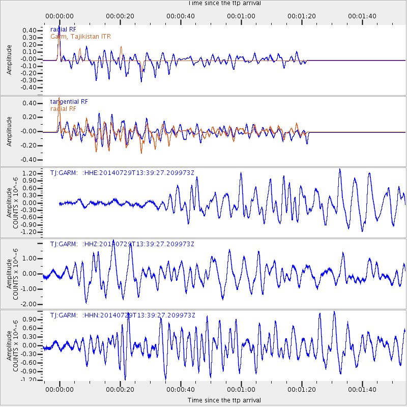
GARM Garm, Tajikistan - Earthquake Result Viewer

| Earthquake location: |
Bismarck Sea |
| Earthquake latitude/longitude: |
-3.5/146.7 |
| Earthquake time(UTC): |
2014/07/29 (210) 13:27:40 GMT |
| Earthquake Depth: |
6.9 km |
| Earthquake Magnitude: |
5.8 MB |
| Earthquake Catalog/Contributor: |
NEIC PDE/NEIC COMCAT |
|
| Network: |
TJ Tajikistan National Seismic Network |
| Station: |
GARM Garm, Tajikistan |
| Lat/Lon: |
39.00 N/70.32 E |
| Elevation: |
1305 m |
|
| Distance: |
81.6 deg |
| Az: |
310.057 deg |
| Baz: |
101.329 deg |
| Ray Param: |
0.04746389 |
| Estimated Moho Depth: |
40.75 km |
| Estimated Crust Vp/Vs: |
1.75 |
| Assumed Crust Vp: |
6.306 km/s |
| Estimated Crust Vs: |
3.614 km/s |
| Estimated Crust Poisson's Ratio: |
0.26 |
|
| Radial Match: |
84.318504 % |
| Radial Bump: |
396 |
| Transverse Match: |
75.881035 % |
| Transverse Bump: |
400 |
| SOD ConfigId: |
769524 |
| Insert Time: |
2014-08-12 13:49:25.267 +0000 |
| GWidth: |
2.5 |
| Max Bumps: |
400 |
| Tol: |
0.001 |
|
Signal To Noise
| Channel | StoN | STA | LTA |
| TJ:GARM: :HHZ:20140729T13:39:27.209973Z | 1.876958 | 2.3569267E-7 | 1.2557163E-7 |
| TJ:GARM: :HHN:20140729T13:39:27.209973Z | 0.96460617 | 8.9684946E-8 | 9.297572E-8 |
| TJ:GARM: :HHE:20140729T13:39:27.209973Z | 1.533137 | 1.08661716E-7 | 7.0875416E-8 |
| Arrivals |
| Ps | 4.9 SECOND |
| PpPs | 17 SECOND |
| PsPs/PpSs | 22 SECOND |


