You are here: Home > Network List > UW - Pacific Northwest Regional Seismic Network Stations List
> Station UMAT Pilot Rock, OR, USA > Earthquake Result Viewer
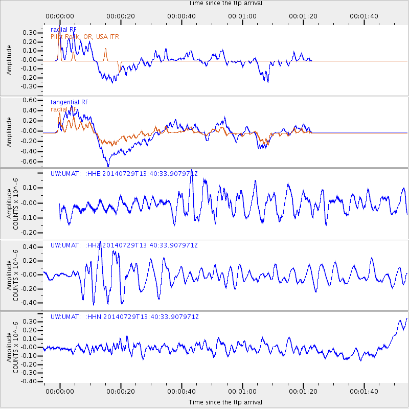
UMAT Pilot Rock, OR, USA - Earthquake Result Viewer
*The percent match for this event was below the threshold and hence no stack was calculated.
| Earthquake location: |
Bismarck Sea |
| Earthquake latitude/longitude: |
-3.5/146.7 |
| Earthquake time(UTC): |
2014/07/29 (210) 13:27:40 GMT |
| Earthquake Depth: |
6.9 km |
| Earthquake Magnitude: |
5.8 MB |
| Earthquake Catalog/Contributor: |
NEIC PDE/NEIC COMCAT |
|
| Network: |
UW Pacific Northwest Regional Seismic Network |
| Station: |
UMAT Pilot Rock, OR, USA |
| Lat/Lon: |
45.29 N/118.96 W |
| Elevation: |
1318 m |
|
| Distance: |
95.5 deg |
| Az: |
45.002 deg |
| Baz: |
270.654 deg |
| Ray Param: |
$rayparam |
*The percent match for this event was below the threshold and hence was not used in the summary stack. |
|
| Radial Match: |
60.861134 % |
| Radial Bump: |
400 |
| Transverse Match: |
43.288677 % |
| Transverse Bump: |
400 |
| SOD ConfigId: |
769524 |
| Insert Time: |
2014-08-12 13:51:12.947 +0000 |
| GWidth: |
2.5 |
| Max Bumps: |
400 |
| Tol: |
0.001 |
|
Signal To Noise
| Channel | StoN | STA | LTA |
| UW:UMAT: :HHZ:20140729T13:40:33.907971Z | 0.7621864 | 2.907088E-8 | 3.814143E-8 |
| UW:UMAT: :HHN:20140729T13:40:33.907971Z | 1.250518 | 7.863974E-8 | 6.288573E-8 |
| UW:UMAT: :HHE:20140729T13:40:33.907971Z | 1.1501533 | 4.121483E-8 | 3.5834205E-8 |
| Arrivals |
| Ps | |
| PpPs | |
| PsPs/PpSs | |


