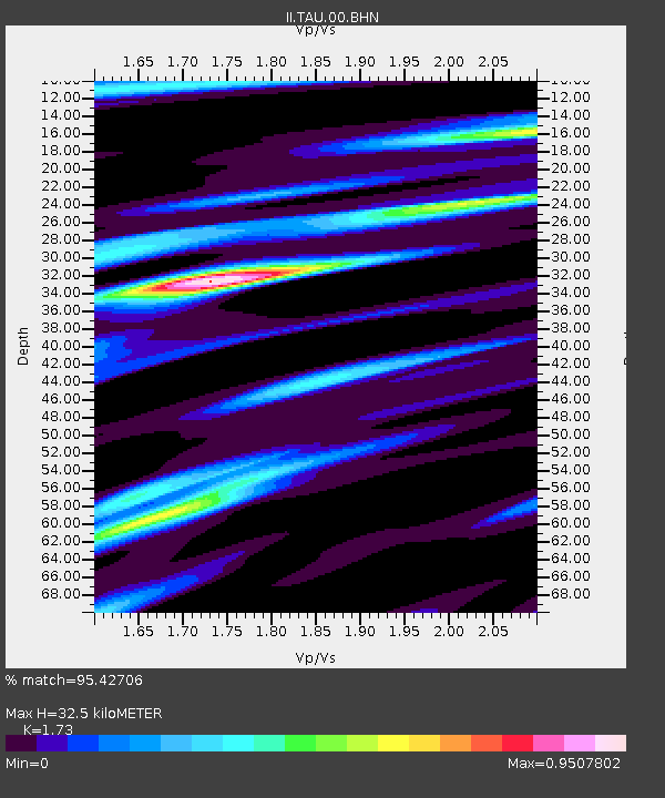
TAU Hobart, Tasmania, Australia - Earthquake Result Viewer

Earthquake location: New Britain Region, P.N.G.
Earthquake latitude/longitude: -5.5/151.8
Earthquake time(UTC): 2000/11/17 (322) 21:01:56 GMT
Earthquake Depth: 33 km
Earthquake Magnitude: 6.2 MB, 8.0 MS, 7.6 MW, 6.9 ME
Earthquake Catalog/Contributor: WHDF/NEIC
Network: II Global Seismograph Network (GSN - IRIS/IDA)
Station: TAU Hobart, Tasmania, Australia
Lat/Lon: 42.91 S/147.32 E
Elevation: 132 m
Distance: 37.5 deg
Az: 185.39 deg
Baz: 7.312 deg
Ray Param: 0.07605889
Estimated Moho Depth: 32.5 km
Estimated Crust Vp/Vs: 1.73
Assumed Crust Vp: 6.477 km/s
Estimated Crust Vs: 3.744 km/s
Estimated Crust Poisson's Ratio: 0.25
Radial Match: 95.42706 %
Radial Bump: 397
Transverse Match: 71.992836 %
Transverse Bump: 400
SOD ConfigId: 3744
Insert Time: 2010-03-02 00:35:32.877 +0000
GWidth: 2.5
Max Bumps: 400
Tol: 0.001

Signal To Noise

ChannelStoNSTALTA
II:TAU:00:BHN:20001117T21:08:36.449015Z1.41808876.059004E-74.2726555E-7
II:TAU:00:BHE:20001117T21:08:36.448008Z0.763309063.4088748E-74.465917E-7
II:TAU:00:BHZ:20001117T21:08:36.448008Z3.26293421.2305131E-63.771186E-7
Arrivals
Ps4.0 SECOND
PpPs13 SECOND
PsPs/PpSs17 SECOND