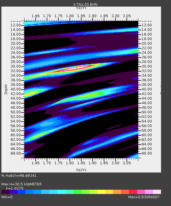
TAU Hobart, Tasmania, Australia - Earthquake Result Viewer
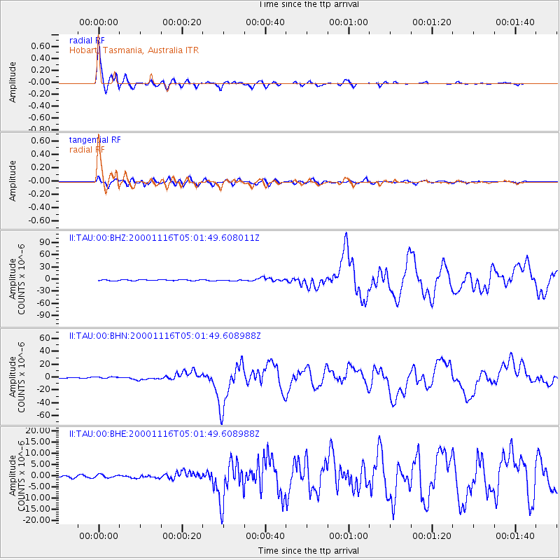
Earthquake location: New Ireland Region, P.N.G.
Earthquake latitude/longitude: -4.0/152.2
Earthquake time(UTC): 2000/11/16 (321) 04:54:56 GMT
Earthquake Depth: 33 km
Earthquake Magnitude: 6.0 MB, 8.2 MS, 8.0 MW, 8.0 ME
Earthquake Catalog/Contributor: WHDF/NEIC
Network: II Global Seismograph Network (GSN - IRIS/IDA)
Station: TAU Hobart, Tasmania, Australia
Lat/Lon: 42.91 S/147.32 E
Elevation: 132 m
Distance: 39.0 deg
Az: 185.662 deg
Baz: 7.699 deg
Ray Param: 0.07517146
Estimated Moho Depth: 30.5 km
Estimated Crust Vp/Vs: 1.83
Assumed Crust Vp: 6.477 km/s
Estimated Crust Vs: 3.544 km/s
Estimated Crust Poisson's Ratio: 0.29
Radial Match: 96.69341 %
Radial Bump: 344
Transverse Match: 85.53996 %
Transverse Bump: 400
SOD ConfigId: 3744
Insert Time: 2010-03-02 00:35:34.471 +0000
GWidth: 2.5
Max Bumps: 400
Tol: 0.001

Signal To Noise

ChannelStoNSTALTA
II:TAU:00:BHN:20001116T05:01:49.608988Z1.95937691.3188675E-66.731056E-7
II:TAU:00:BHE:20001116T05:01:49.608988Z1.5528437.0444327E-74.5364746E-7
II:TAU:00:BHZ:20001116T05:01:49.608011Z1.14754411.3939936E-61.2147624E-6
Arrivals
Ps4.2 SECOND
PpPs12 SECOND
PsPs/PpSs17 SECOND