You are here: Home > Network List > NI - North-East Italy Broadband Network Stations List
> Station ZOU2 Zouf Plan > Earthquake Result Viewer
ZOU2 Zouf Plan - Earthquake Result Viewer
| Earthquake location: |
Southern Iran |
| Earthquake latitude/longitude: |
26.4/53.5 |
| Earthquake time(UTC): |
2014/07/30 (211) 01:32:09 GMT |
| Earthquake Depth: |
5.2 km |
| Earthquake Magnitude: |
5.6 MB, 5.3 MWB |
| Earthquake Catalog/Contributor: |
NEIC PDE/NEIC COMCAT |
|
| Network: |
NI North-East Italy Broadband Network |
| Station: |
ZOU2 Zouf Plan |
| Lat/Lon: |
46.56 N/12.97 E |
| Elevation: |
1896 m |
|
| Distance: |
37.8 deg |
| Az: |
312.918 deg |
| Baz: |
107.852 deg |
| Ray Param: |
0.07594358 |
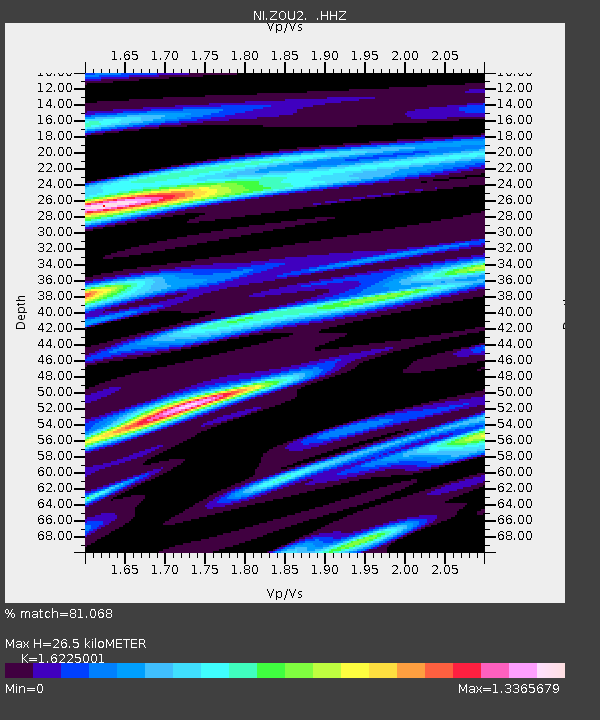
| Estimated Moho Depth: |
26.5 km |
| Estimated Crust Vp/Vs: |
1.62 |
| Assumed Crust Vp: |
6.35 km/s |
| Estimated Crust Vs: |
3.914 km/s |
| Estimated Crust Poisson's Ratio: |
0.19 |
|
| Radial Match: |
81.068 % |
| Radial Bump: |
365 |
| Transverse Match: |
53.19538 % |
| Transverse Bump: |
400 |
| SOD ConfigId: |
769524 |
| Insert Time: |
2014-08-13 01:59:25.290 +0000 |
| GWidth: |
2.5 |
| Max Bumps: |
400 |
| Tol: |
0.001 |
|

Signal To Noise
| Channel | StoN | STA | LTA |
| NI:ZOU2: :HHZ:20140730T01:38:55.617994Z | 6.242213 | 4.2367034E-7 | 6.7871824E-8 |
| NI:ZOU2: :HHN:20140730T01:38:55.617994Z | 1.8314667 | 1.4616981E-7 | 7.981025E-8 |
| NI:ZOU2: :HHE:20140730T01:38:55.617994Z | 3.3692887 | 2.4188472E-7 | 7.1791035E-8 |
| Arrivals |
| Ps | 2.8 SECOND |
| PpPs | 10 SECOND |
| PsPs/PpSs | 13 SECOND |


