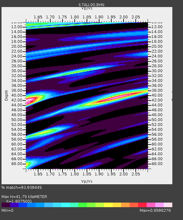
TAU Hobart, Tasmania, Australia - Earthquake Result Viewer

Earthquake location: New Britain Region, P.N.G.
Earthquake latitude/longitude: -5.6/149.6
Earthquake time(UTC): 1999/04/05 (095) 11:08:04 GMT
Earthquake Depth: 150 km
Earthquake Magnitude: 6.2 MB, 7.0 MS, 7.4 MW, 7.3 ME
Earthquake Catalog/Contributor: WHDF/NEIC
Network: II Global Seismograph Network (GSN - IRIS/IDA)
Station: TAU Hobart, Tasmania, Australia
Lat/Lon: 42.91 S/147.32 E
Elevation: 132 m
Distance: 37.2 deg
Az: 182.73 deg
Baz: 3.7 deg
Ray Param: 0.07571882
Estimated Moho Depth: 41.75 km
Estimated Crust Vp/Vs: 1.61
Assumed Crust Vp: 6.477 km/s
Estimated Crust Vs: 4.029 km/s
Estimated Crust Poisson's Ratio: 0.18
Radial Match: 93.939445 %
Radial Bump: 400
Transverse Match: 59.65514 %
Transverse Bump: 400
SOD ConfigId: 4480
Insert Time: 2010-03-02 00:35:52.160 +0000
GWidth: 2.5
Max Bumps: 400
Tol: 0.001

Signal To Noise

ChannelStoNSTALTA
II:TAU:00:BHN:19990405T11:14:30.519012Z2.41723943.0954016E-61.2805524E-6
II:TAU:00:BHE:19990405T11:14:30.519012Z1.31439521.542053E-61.1732035E-6
II:TAU:00:BHZ:19990405T11:14:30.515991Z1.31614159.790331E-77.4386617E-7
Arrivals
Ps4.3 SECOND
PpPs15 SECOND
PsPs/PpSs20 SECOND