You are here: Home > Network List > II - Global Seismograph Network (GSN - IRIS/IDA) Stations List
> Station TAU Hobart, Tasmania, Australia > Earthquake Result Viewer
TAU Hobart, Tasmania, Australia - Earthquake Result Viewer
| Earthquake location: |
Fiji Islands Region |
| Earthquake latitude/longitude: |
-21.4/-176.5 |
| Earthquake time(UTC): |
1999/04/13 (103) 10:38:48 GMT |
| Earthquake Depth: |
164 km |
| Earthquake Magnitude: |
6.4 MB, 6.8 MW, 6.8 MW |
| Earthquake Catalog/Contributor: |
WHDF/NEIC |
|
| Network: |
II Global Seismograph Network (GSN - IRIS/IDA) |
| Station: |
TAU Hobart, Tasmania, Australia |
| Lat/Lon: |
42.91 S/147.32 E |
| Elevation: |
132 m |
|
| Distance: |
37.0 deg |
| Az: |
226.162 deg |
| Baz: |
66.17 deg |
| Ray Param: |
0.07578004 |
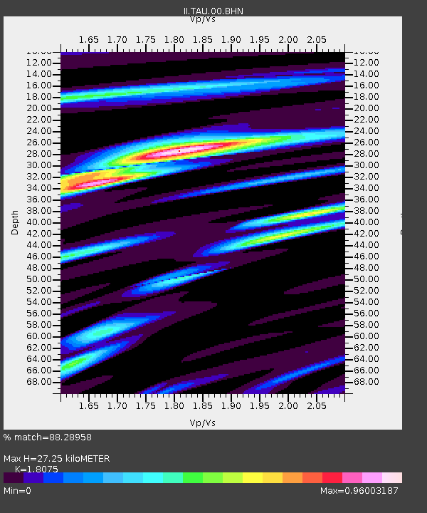
| Estimated Moho Depth: |
27.25 km |
| Estimated Crust Vp/Vs: |
1.81 |
| Assumed Crust Vp: |
6.477 km/s |
| Estimated Crust Vs: |
3.583 km/s |
| Estimated Crust Poisson's Ratio: |
0.28 |
|
| Radial Match: |
88.28958 % |
| Radial Bump: |
344 |
| Transverse Match: |
58.68008 % |
| Transverse Bump: |
400 |
| SOD ConfigId: |
4480 |
| Insert Time: |
2010-03-02 00:35:53.783 +0000 |
| GWidth: |
2.5 |
| Max Bumps: |
400 |
| Tol: |
0.001 |
|
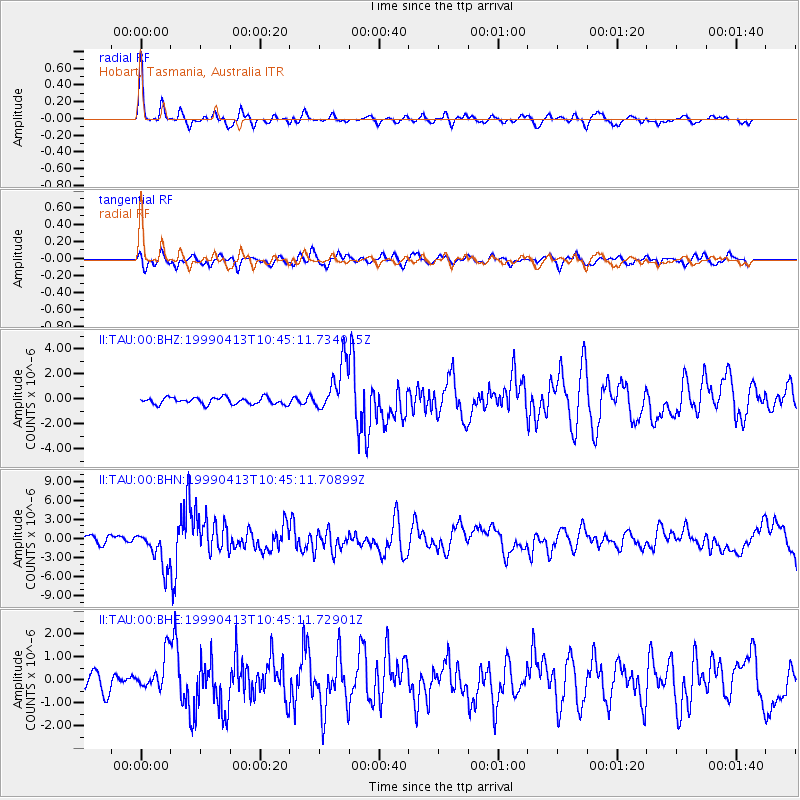
Signal To Noise
| Channel | StoN | STA | LTA |
| II:TAU:00:BHN:19990413T10:45:11.70899Z | 3.4536414 | 2.925867E-6 | 8.471832E-7 |
| II:TAU:00:BHE:19990413T10:45:11.72901Z | 0.7939677 | 7.8041546E-7 | 9.829309E-7 |
| II:TAU:00:BHZ:19990413T10:45:11.734015Z | 7.5121274 | 1.9973531E-6 | 2.658838E-7 |
| Arrivals |
| Ps | 3.7 SECOND |
| PpPs | 11 SECOND |
| PsPs/PpSs | 15 SECOND |


