You are here: Home > Network List > II - Global Seismograph Network (GSN - IRIS/IDA) Stations List
> Station TAU Hobart, Tasmania, Australia > Earthquake Result Viewer
TAU Hobart, Tasmania, Australia - Earthquake Result Viewer
| Earthquake location: |
Santa Cruz Islands |
| Earthquake latitude/longitude: |
-11.7/166.4 |
| Earthquake time(UTC): |
2001/01/19 (019) 08:10:14 GMT |
| Earthquake Depth: |
50 km |
| Earthquake Magnitude: |
5.7 MB, 6.1 MS, 6.4 MW, 6.3 MW |
| Earthquake Catalog/Contributor: |
WHDF/NEIC |
|
| Network: |
II Global Seismograph Network (GSN - IRIS/IDA) |
| Station: |
TAU Hobart, Tasmania, Australia |
| Lat/Lon: |
42.91 S/147.32 E |
| Elevation: |
132 m |
|
| Distance: |
35.3 deg |
| Az: |
204.556 deg |
| Baz: |
33.65 deg |
| Ray Param: |
0.07719292 |
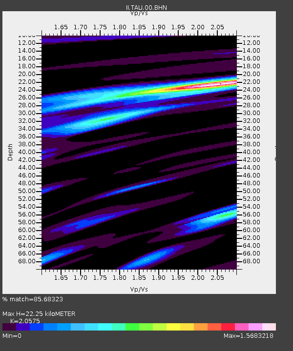
| Estimated Moho Depth: |
22.25 km |
| Estimated Crust Vp/Vs: |
2.06 |
| Assumed Crust Vp: |
6.477 km/s |
| Estimated Crust Vs: |
3.148 km/s |
| Estimated Crust Poisson's Ratio: |
0.35 |
|
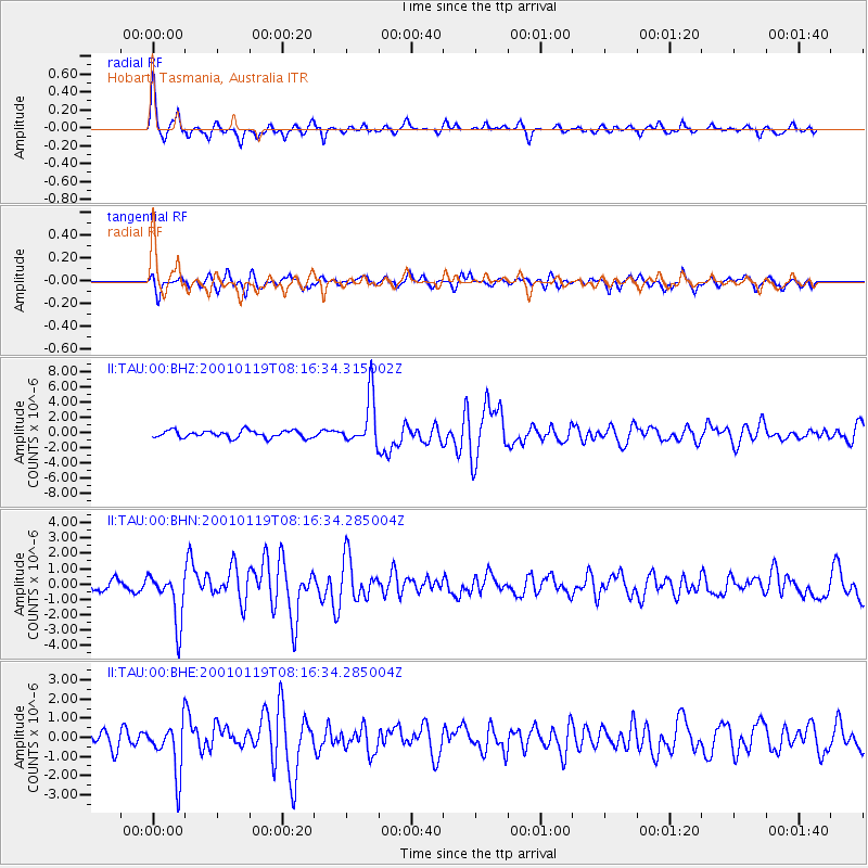
| Radial Match: |
85.68323 % |
| Radial Bump: |
307 |
| Transverse Match: |
64.7476 % |
| Transverse Bump: |
400 |
| SOD ConfigId: |
3744 |
| Insert Time: |
2010-03-02 00:36:00.196 +0000 |
| GWidth: |
2.5 |
| Max Bumps: |
400 |
| Tol: |
0.001 |
|
Signal To Noise
| Channel | StoN | STA | LTA |
| II:TAU:00:BHN:20010119T08:16:34.285004Z | 4.4302335 | 1.6424557E-6 | 3.7073792E-7 |
| II:TAU:00:BHE:20010119T08:16:34.285004Z | 2.3363757 | 1.3347014E-6 | 5.7127E-7 |
| II:TAU:00:BHZ:20010119T08:16:34.315002Z | 6.812404 | 3.2558894E-6 | 4.7793543E-7 |
| Arrivals |
| Ps | 3.9 SECOND |
| PpPs | 9.8 SECOND |
| PsPs/PpSs | 14 SECOND |


