You are here: Home > Network List > II - Global Seismograph Network (GSN - IRIS/IDA) Stations List
> Station TAU Hobart, Tasmania, Australia > Earthquake Result Viewer
TAU Hobart, Tasmania, Australia - Earthquake Result Viewer
| Earthquake location: |
Northern Molucca Sea |
| Earthquake latitude/longitude: |
1.3/126.2 |
| Earthquake time(UTC): |
2001/02/24 (055) 07:23:48 GMT |
| Earthquake Depth: |
35 km |
| Earthquake Magnitude: |
6.6 MB, 7.0 MS, 7.1 MW, 7.1 ME |
| Earthquake Catalog/Contributor: |
WHDF/NEIC |
|
| Network: |
II Global Seismograph Network (GSN - IRIS/IDA) |
| Station: |
TAU Hobart, Tasmania, Australia |
| Lat/Lon: |
42.91 S/147.32 E |
| Elevation: |
132 m |
|
| Distance: |
47.9 deg |
| Az: |
159.144 deg |
| Baz: |
331.023 deg |
| Ray Param: |
0.06963212 |
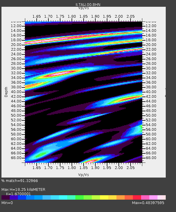
| Estimated Moho Depth: |
18.25 km |
| Estimated Crust Vp/Vs: |
1.67 |
| Assumed Crust Vp: |
6.477 km/s |
| Estimated Crust Vs: |
3.878 km/s |
| Estimated Crust Poisson's Ratio: |
0.22 |
|
| Radial Match: |
91.32966 % |
| Radial Bump: |
400 |
| Transverse Match: |
81.770615 % |
| Transverse Bump: |
400 |
| SOD ConfigId: |
3744 |
| Insert Time: |
2010-03-02 00:36:08.327 +0000 |
| GWidth: |
2.5 |
| Max Bumps: |
400 |
| Tol: |
0.001 |
|
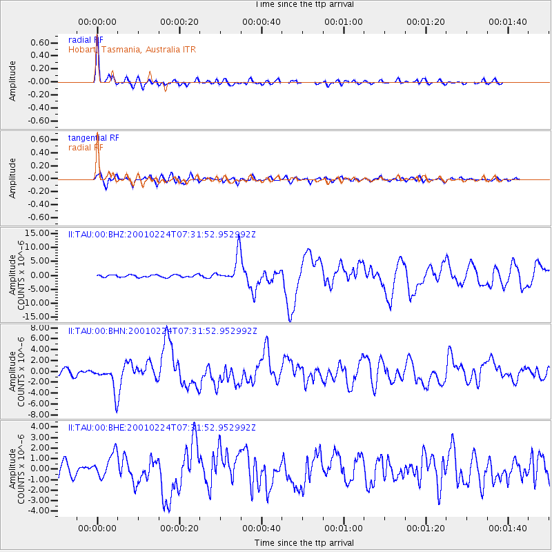
Signal To Noise
| Channel | StoN | STA | LTA |
| II:TAU:00:BHN:20010224T07:31:52.952992Z | 4.683308 | 2.457642E-6 | 5.247662E-7 |
| II:TAU:00:BHE:20010224T07:31:52.952992Z | 2.5328667 | 1.1974236E-6 | 4.7275424E-7 |
| II:TAU:00:BHZ:20010224T07:31:52.952992Z | 12.125456 | 5.2010278E-6 | 4.2893458E-7 |
| Arrivals |
| Ps | 2.0 SECOND |
| PpPs | 7.0 SECOND |
| PsPs/PpSs | 9.1 SECOND |


