You are here: Home > Network List > II - Global Seismograph Network (GSN - IRIS/IDA) Stations List
> Station TAU Hobart, Tasmania, Australia > Earthquake Result Viewer
TAU Hobart, Tasmania, Australia - Earthquake Result Viewer

| Earthquake location: |
Vanuatu Islands |
| Earthquake latitude/longitude: |
-15.1/167.4 |
| Earthquake time(UTC): |
1997/11/15 (319) 18:59:24 GMT |
| Earthquake Depth: |
123 km |
| Earthquake Magnitude: |
6.4 MB, 7.0 UNKNOWN, 6.8 ME |
| Earthquake Catalog/Contributor: |
WHDF/NEIC |
|
| Network: |
II Global Seismograph Network (GSN - IRIS/IDA) |
| Station: |
TAU Hobart, Tasmania, Australia |
| Lat/Lon: |
42.91 S/147.32 E |
| Elevation: |
132 m |
|
| Distance: |
32.6 deg |
| Az: |
207.895 deg |
| Baz: |
37.948 deg |
| Ray Param: |
0.078238055 |
| Estimated Moho Depth: |
30.5 km |
| Estimated Crust Vp/Vs: |
1.87 |
| Assumed Crust Vp: |
6.477 km/s |
| Estimated Crust Vs: |
3.468 km/s |
| Estimated Crust Poisson's Ratio: |
0.30 |
|
| Radial Match: |
94.60809 % |
| Radial Bump: |
325 |
| Transverse Match: |
83.2357 % |
| Transverse Bump: |
400 |
| SOD ConfigId: |
4480 |
| Insert Time: |
2010-03-02 00:36:11.303 +0000 |
| GWidth: |
2.5 |
| Max Bumps: |
400 |
| Tol: |
0.001 |
|
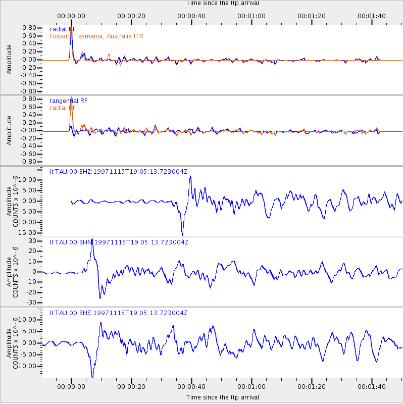
Signal To Noise
| Channel | StoN | STA | LTA |
| II:TAU:00:BHN:19971115T19:05:13.723004Z | 2.1880963 | 1.2977994E-6 | 5.9311805E-7 |
| II:TAU:00:BHE:19971115T19:05:13.723004Z | 1.5529526 | 7.1110617E-7 | 4.5790588E-7 |
| II:TAU:00:BHZ:19971115T19:05:13.723004Z | 1.3983018 | 6.990375E-7 | 4.999189E-7 |
| Arrivals |
| Ps | 4.4 SECOND |
| PpPs | 13 SECOND |
| PsPs/PpSs | 17 SECOND |


